This map is based on the data of patients cases till 30 March 2020:
Category Archives: GIS Vector Data
Corona Spread in Lahore
This map is based on the data of patients admitted to the following hospital and represent the cases till 30 March 2020:
Bahria Hospital,
Childern Hospital
Ganga Ram Hospital
General Hospital
Jinnah Hospital
Mayo Hospital
National Hospital
PKLI Hospital
Services Hospital
Shahdara Teaching Hospital
Sheikh Zaid Hospital
Social Security Hospital
Mobile Data Collection with Preloaded data
Background: 
Recently I was asked to design a mobile based data collection and management system to collect data of sugarcane growers in Pakistan. The objective was to develop a data collection and management system which can be used to collect data from sugar cane growers using android based devices. The collected data required to contain text, numeric and pictures along with geographic shapes (polygons) of the sugarcane fields.
The field enumerators were expected to have low education level so it was desired to make the mobile data collection as intuitive and user friendly as possible. The weather and field conditions were tough requiring considerations.
The collected data was to be audited by supervisors through a web interface where they wanted to view and verify the collected data as well as the location, shape and size of sugarcane field. They wanted to view the polygon of sugarcane filed overlaid on satellite image with the ability to modify coordinates of polygon shape.
Additionally, it was required to have some mechanism in which existing data of sugarcane growers is made available on mobile data collection devices so that enumerator does not need to fill in all data fields. Instead they can simply verify if the existing data was correct.
Form Design with Preloaded data:
We decided to base our work on Open Data Kit with customized data collection forms and reporting server. ODK Collect 1.4.3 allows the data preloading in new round of survey. We took advantage of that and created a survey form with associated database of existing grower information. Some key technical aspects in designing such forms include the following:
- Create a .csv file containing the data you want to use as pre-loaded in your questions. For example our csv name is SCGDV1.csv
- The .csv file must contain a column with name ending with “_key”. This column will be used for lookup. For example in our case we used “grower_id_key”
- The column names for other columns should also be short and unique.
- Create a simple form using ODK build or any other xml form builder of your choice
- Open the xml for in note pad or any other xml editor for advance changes
- Search for “<bind nodeset” and you will reach in the part of form containing data nodes
- Initially they will look like:
<bind nodeset="/data/grower_id" type="int"/>
<bind nodeset="/data/name" type="string" required="true()"/>
<bind nodeset="/data/father_name" type="string"/>
<bind nodeset="/data/nic" type="int" required="true()"/>
<bind nodeset="/data/land" type="int"/>
<bind nodeset="/data/location" type="geopoint"/>
- Add pulldata() function to desired nodesets where you want to have preloaded data.
- The syntax will be like
calculate="pulldata('SCGDV1', 'name', 'grower_id_key', /data/grower_id)"calculate=”pulldata(‘SCGDV1’, ‘name’, ‘grower_id_key’, /data/grower_id)”
- Where SCGDV1 is name of csv file, “name” is the column heading whose value you want to pull against grower_id given in /data/grower_id while “grower_id_key” will be used for searching that name.
- Suppose you entered 15 as a grower_id in a question and you use pulldata() function to fetch name of the grower having id 15 from the csv file. So it will search for 15 in “grower_id_key” column and will find the corresponding name for that record and fill the Name question with what it found.
- pulldata() function is used with a calculate command with each nodeset and resultantly code looks like this
<bind nodeset="/data/grower_id" type="int"/>
<bind calculate="pulldata('SCGDV1', 'name', 'grower_id_key', /data/grower_id)" nodeset="/data/name" type="string" required="true()"/>
<bind calculate="pulldata('SCGDV1', 'father_name', 'grower_id_key', /data/grower_id)" nodeset="/data/father_name" type="string"/>
<bind calculate="number(pulldata('SCGDV1', 'nic', 'grower_id_key', /data/grower_id))" nodeset="/data/nic" type="int" required="true()"/>
<bind calculate="number(pulldata('SCGDV1', 'land', 'grower_id_key', /data/grower_id))" nodeset="/data/land" type="int"/>
<bind nodeset="/data/location" type="geopoint"/>
- Even when they are numbers, data fields pulled from a .csv file are considered to be text strings. Thus, you may sometimes need to use the int() or number() functions to convert a pre-loaded field into numeric form. In my case int() did not worked but number() works fine as it can be seen above. I had to use this function for each and every nodeset where data type was integer. Otherwise it gives error.
- Once form is complete, test is using ODK Validate and upload in your aggregate along with csv file. Deploy on your mobile and it works perfect.
Peri Urban Structure Plan of Okara City
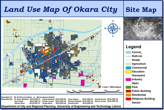
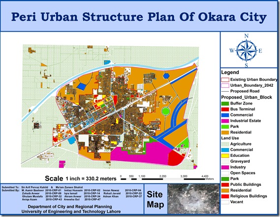
A group of urban planning students from University of Engineering and Technology (CRP-10) including M. Aamir Basheer, Imtiaz Hussain, Imran Nawaz, Zohaib Anwar, Iqra Ismail, Rohail Javaid, Ghulam Mustafa, Akram Anwar, Adnan Khan, Aniqa Azam, Areesha Gul has prepared GIS based peri urban structure plan of Okara City using high resolution satellite image. The map includes Points of interest , Existing urban boundary , Existing land uses, Proposed Roads, and Proposed urban block.
This is a true addition to the existing effort on GIS mapping of Okara which was done by Munawar and Nausheen (CRP-08) in 2009. Previous map can be seen HERE.
Peri Urban Plan of Hujra Shah Muqeem
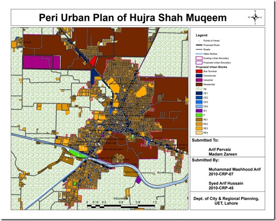
An interesting effort by Muhammad Mashhood and Arif Hussain, students at Engineering University, Department of City and Regional Planning.
Its GIS based map of Hujra Shah Muqeem containing base map, existing land uses, road network, points of interest, existing and proposed urban area boundaries, water bodies and proposed land uses for future growth.
Airline Route Mapper
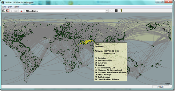
Airline Route Mapper is a Windows program for exploring route maps of over 550 airlines. You can search by airports or airlines.
Download AirlineRouteMapper
Originally available at http://arm.64hosts.com/
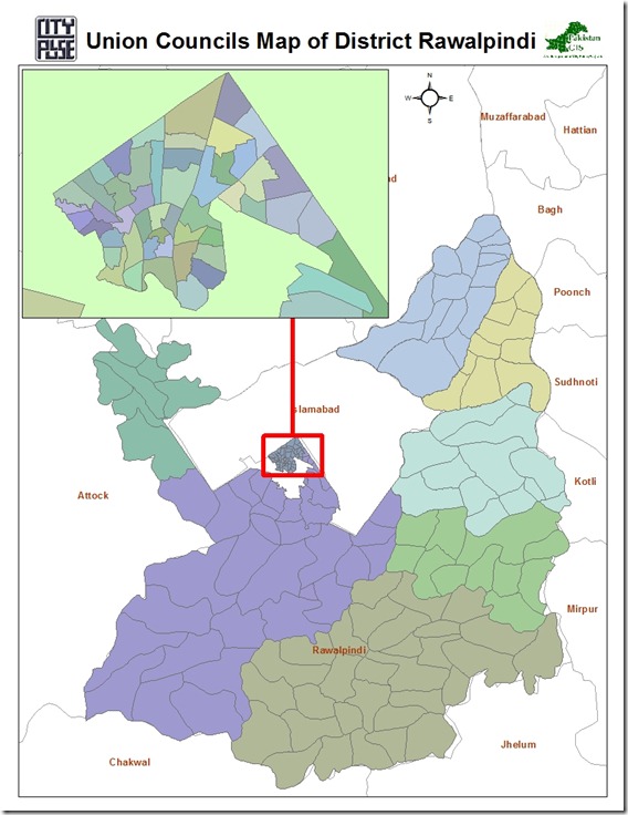
Union Council Boundaries of Rawalpindi City and District
This GIS datasets contains polygonal boundaries for 170 union councils of Rawalpindi urban area as well as Rawalpindi District. This geo-dataset is more reliable for urban area and seems to be less accurate for rural towns.
.::Click HERE to request for this data set::.
Vector Datasets (ESRI Shapefiles)
Currently following vector datasets are available in ESRI Shape files Format at this blog:
Administrative Boundaries Maps:
- National and Provincial Boundaries of Pakistan (Admin Level 0 and 1)
- District Boundaries of Pakistan (Admin Level 2)
- Tehsil Boundaries of Pakistan (Admin Level 3)
- Union Council Map (Admin level 4) of District Barkhan – Balochistan
-
Union Council Map (Admin level 4) of District Jaffarabad – Balochistan
-
Union Council Map (Admin level 4) of District Killa Saifullah – Balochistan
-
Union Council Map (Admin level 4) of District Kohlu – Balochistan
-
Union Council Map (Admin level 4) of District Loralai – Balochistan
-
Union Council Map (Admin level 4) of District Nasirabad – Balochistan
-
Union Council Map (Admin level 4) of District Sibi – Balochistan
Khyber Pakhtunkhwa
-
Union Council Map (Admin level 4) of District Abbottabad – KPK
-
Union Council Map (Admin level 4) of District Bannu – KPK
-
Union Council Map (Admin level 4) of District Batagram – KPK
-
Union Council Map (Admin level 4) of District Buner – KPK
-
Union Council Map (Admin level 4) of District Charsadda – KPK
-
Union Council Map (Admin level 4) of District Chitral – KPK
-
Union Council Map (Admin level 4) of District Dera Ismail Khan – KPK
-
Union Council Map (Admin level 4) of District Hangu – KPK
-
Union Council Map (Admin level 4) of District Haripur – KPK
-
Union Council Map (Admin level 4) of District Karak – KPK
-
Union Council Map (Admin level 4) of District Kohat – KPK
-
Union Council Map (Admin level 4) of District Kohistan – KPK
-
Union Council Map (Admin level 4) of District Lakki Marwat – KPK
-
Union Council Map (Admin level 4) of District Lower Dir – KPK
-
Union Council Map (Admin level 4) of District Malakand P.a. – KPK
-
Union Council Map (Admin level 4) of District Mansehra – KPK
-
Union Council Map (Admin level 4) of District Mardan – KPK
-
Union Council Map (Admin level 4) of District Nowshera – KPK
-
Union Council Map (Admin level 4) of District Peshawar – KPK
-
Union Council Map (Admin level 4) of District Shangla – KPK
-
Union Council Map (Admin level 4) of District Swabi – KPK
-
Union Council Map (Admin level 4) of District Swat – KPK
-
Union Council Map (Admin level 4) of District Tank – KPK
-
Union Council Map (Admin level 4) of District Upper Dir – KPK
Punjab
-
Union Council Map (Admin level 4) of District Bahawalpur – Punjab
-
Union Council Map (Admin level 4) of District Bhakkar – Punjab
-
Union Council Map (Admin level 4) of District Dera Ghazi Khan – Punjab
-
Union Council Map (Admin level 4) of District Jhang – Punjab
-
Union Council Map (Admin level 4) of District Khushab – Punjab
-
Union Council Map (Admin level 4) of District Layyah – Punjab
-
Union Council Map (Admin level 4) of District Mianwali – Punjab
-
Union Council Map (Admin level 4) of District Multan – Punjab
-
Union Council Map (Admin level 4) of District Muzaffargarh – Punjab
-
Union Council Map (Admin level 4) of District Rahim Yar Khan – Punjab
-
Union Council Map (Admin level 4) of District Rajanpur – Punjab
Sindh
-
Union Council Map (Admin level 4) of District Dadu – Sindh
-
Union Council Map (Admin level 4) of District Ghotki – Sindh
-
Union Council Map (Admin level 4) of District Hyderabad – Sindh
-
Union Council Map (Admin level 4) of District Jacobabad – Sindh
-
Union Council Map (Admin level 4) of District Jamshoro – Sindh
-
Union Council Map (Admin level 4) of District Kashmore – Sindh
-
Union Council Map (Admin level 4) of District Khairpur – Sindh
-
Union Council Map (Admin level 4) of District Larkana – Sindh
-
Union Council Map (Admin level 4) of District Matiari – Sindh
-
Union Council Map (Admin level 4) of District Naushahro Feroze – Sindh
-
Union Council Map (Admin level 4) of District Qambar Shahdadkot – Sindh
-
Union Council Map (Admin level 4) of District Shaheed Benazirabad – Sindh
-
Union Council Map (Admin level 4) of District Shikarpur – Sindh
-
Union Council Map (Admin level 4) of District Sukkur – Sindh
-
Union Council Map (Admin level 4) of District Tando Muhammad Khan – Sindh
-
Union Council Map (Admin level 4) of District Thatta – Sindh
Urban Union Councils:
Urban Area Maps:
-
Haripur GIS Map (ESRI Format)
-
Peshawar GIS Map (ESRI Format)
-
Mianwali Tehsil GIS Map (ESRI Format)
-
Quetta GIS Map (ESRI Format)
-
Gilgit GIS Map (ESRI Format)
-
Nankana Sahib GIS Map (ESRI Format)
-
Jaranwala GIS Map (ESRI Format)
-
Pindi Bhattian GIS Map (ESRI Format)
-
Khangah Dogran GIS Map (ESRI Format)
-
Chiniot GIS Map (ESRI Format)
-
Chakwal GIS Map (ESRI Format)
-
Attock GIS based Land use Map (ESRI Format)
-
Faisalabad GIS based Land use Map (ESRI Format)
-
Village Kesar Garh (District Kasur) GIS Based Landuse Map (ESRI Format)
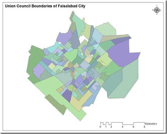
Union Council Boundaries of Faisalabad City
This GIS map consists of polygonal boundaries for 118 union councils of Faisalabad urban area. It has been developed and generously shared by Nasar min Allah Bhalli (M.Phil) from Department of geography, GC University Faisalabad.
.::Click HERE to request for this data set::.
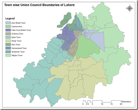
Town wise Union Council Boundaries of Lahore
This GIS map consists of polygonal boundaries for 151 union councils of Lahore urban area divided in 11 Towns.
Special thank to our very Valued Contributor for Lahore.
.::Click HERE to request for this data set::.

