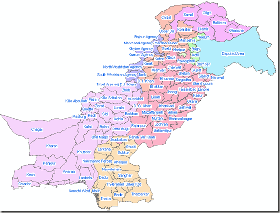
“The Districts of Pakistan are the second order administrative divisions of Pakistan. Districts were the third order of administrative divisions, below provinces and “divisions“, until the reforms of August 2000, when “divisions” were abolished. Districts now form the top tier of a three-tier system of local government with the two lower tiers composed of approximately 400 tehsils and more than six thousand union councils.
Prior to 2001, there were 106 districts but with the reorganisation, these were reduced to 102 by the merger of the five districts of Karachi Central, Karachi East, Karachi South, Karachi West and Malir to form Karachi District. The five districts had formed the division of Karachi which was abolished. The number of districts rose to 106 again in December 2004, when four new districts were created in the province of Sindh of which one (Umerkot) had existed until 2000 and three districts (Kashmore, Qambar and Jamshoro) were newly created.
In May 2005, the Punjab provincial government created a new district[2] by raising the status of Nankana Sahib from a tehsil of Sheikhpura District to a district in its own right.
In Azad Kashmir, the second tier of government is formed by two administrative divisions (Muzaffarabad) & (Mirpur) with a third tier of eight districts. In the Northern Areas, there are six districts divided between two regions of Gilgit and Baltistan; Baltistan being the part of Ladakh in Pakistani control.” Source: Wikipedia
An overview of data is given in table below:
| Subdivision |
Number of districts
|
| Balochistan Province |
27
|
| North-West Frontier Province | 24 |
| Punjab Province | 36 |
| Sindh Province | 23 |
| Islamabad Capital Territory | 1 |
| Federally Administered Tribal Areas | 7 tribal agencies plus 6 frontier regions |
| Azad Kashmir | 8 |
| Northern Areas | 6 |
| Pakistan | 128 districts plus 7 tribal agencies |
| Snapshot of Dataset; District Boundaries of Pakistan |
 |
| .::Click HERE to request for this data set::. |
