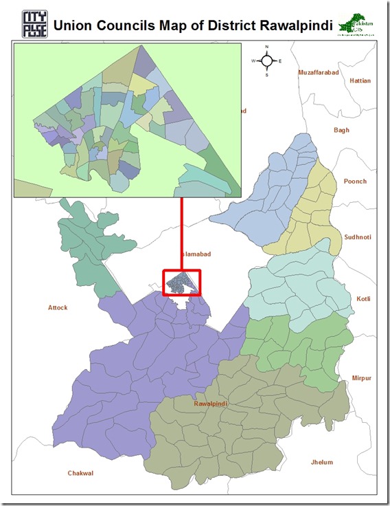
Union Council Boundaries of Rawalpindi City and District

This GIS datasets contains polygonal boundaries for 170 union councils of Rawalpindi urban area as well as Rawalpindi District. This geo-dataset is more reliable for urban area and seems to be less accurate for rural towns.

Rawalpindi UCs Pakistan GIS

.::Click HERE to request for this data set::.

Vector Datasets (ESRI Shapefiles)

Currently following vector datasets are available in ESRI Shape files Format at this blog:

Administrative Boundaries Maps:

  1. National and Provincial Boundaries of Pakistan (Admin Level 0 and 1)
  2. District Boundaries of Pakistan (Admin Level 2)
  3. Tehsil Boundaries of Pakistan (Admin Level 3)
  4. Union Council Map (Admin level 4) of District Barkhan – Balochistan
  5. Union Council Map (Admin level 4) of District Jaffarabad – Balochistan

  6. Union Council Map (Admin level 4) of District Killa Saifullah – Balochistan

  7. Union Council Map (Admin level 4) of District Kohlu – Balochistan

  8. Union Council Map (Admin level 4) of District Loralai – Balochistan

  9. Union Council Map (Admin level 4) of District Nasirabad – Balochistan

  10. Union Council Map (Admin level 4) of District Sibi – Balochistan

Khyber Pakhtunkhwa

  1. Union Council Map (Admin level 4) of District Abbottabad – KPK

  2. Union Council Map (Admin level 4) of District Bannu – KPK

  3. Union Council Map (Admin level 4) of District Batagram – KPK

  4. Union Council Map (Admin level 4) of District Buner – KPK

  5. Union Council Map (Admin level 4) of District Charsadda – KPK

  6. Union Council Map (Admin level 4) of District Chitral – KPK

  7. Union Council Map (Admin level 4) of District Dera Ismail Khan – KPK

  8. Union Council Map (Admin level 4) of District Hangu – KPK

  9. Union Council Map (Admin level 4) of District Haripur – KPK

  10. Union Council Map (Admin level 4) of District Karak – KPK

  11. Union Council Map (Admin level 4) of District Kohat – KPK

  12. Union Council Map (Admin level 4) of District Kohistan – KPK

  13. Union Council Map (Admin level 4) of District Lakki Marwat – KPK

  14. Union Council Map (Admin level 4) of District Lower Dir – KPK

  15. Union Council Map (Admin level 4) of District Malakand P.a. – KPK

  16. Union Council Map (Admin level 4) of District Mansehra – KPK

  17. Union Council Map (Admin level 4) of District Mardan – KPK

  18. Union Council Map (Admin level 4) of District Nowshera – KPK

  19. Union Council Map (Admin level 4) of District Peshawar – KPK

  20. Union Council Map (Admin level 4) of District Shangla – KPK

  21. Union Council Map (Admin level 4) of District Swabi – KPK

  22. Union Council Map (Admin level 4) of District Swat – KPK

  23. Union Council Map (Admin level 4) of District Tank – KPK

  24. Union Council Map (Admin level 4) of District Upper Dir – KPK

Punjab

  1. Union Council Map (Admin level 4) of District Bahawalpur – Punjab

  2. Union Council Map (Admin level 4) of District Bhakkar – Punjab

  3. Union Council Map (Admin level 4) of District Dera Ghazi Khan – Punjab

  4. Union Council Map (Admin level 4) of District Jhang – Punjab

  5. Union Council Map (Admin level 4) of District Khushab – Punjab

  6. Union Council Map (Admin level 4) of District Layyah – Punjab

  7. Union Council Map (Admin level 4) of District Mianwali – Punjab

  8. Union Council Map (Admin level 4) of District Multan – Punjab

  9. Union Council Map (Admin level 4) of District Muzaffargarh – Punjab

  10. Union Council Map (Admin level 4) of District Rahim Yar Khan – Punjab

  11. Union Council Map (Admin level 4) of District Rajanpur – Punjab

Sindh

  1. Union Council Map (Admin level 4) of District Dadu – Sindh

  2. Union Council Map (Admin level 4) of District Ghotki – Sindh

  3. Union Council Map (Admin level 4) of District Hyderabad – Sindh

  4. Union Council Map (Admin level 4) of District Jacobabad – Sindh

  5. Union Council Map (Admin level 4) of District Jamshoro – Sindh

  6. Union Council Map (Admin level 4) of District Kashmore – Sindh

  7. Union Council Map (Admin level 4) of District Khairpur – Sindh

  8. Union Council Map (Admin level 4) of District Larkana – Sindh

  9. Union Council Map (Admin level 4) of District Matiari – Sindh

  10. Union Council Map (Admin level 4) of District Naushahro Feroze – Sindh

  11. Union Council Map (Admin level 4) of District Qambar Shahdadkot – Sindh

  12. Union Council Map (Admin level 4) of District Shaheed Benazirabad – Sindh

  13. Union Council Map (Admin level 4) of District Shikarpur – Sindh

  14. Union Council Map (Admin level 4) of District Sukkur – Sindh

  15. Union Council Map (Admin level 4) of District Tando Muhammad Khan – Sindh

  16. Union Council Map (Admin level 4) of District Thatta – Sindh

Urban Union Councils:

Urban Area Maps:

  1. Haripur GIS Map (ESRI Format)
  2. Peshawar GIS Map (ESRI Format)
  3. Mianwali Tehsil GIS Map (ESRI Format)
  4. Quetta GIS Map (ESRI Format)
  5. Gilgit GIS Map (ESRI Format)
  6. Nankana Sahib GIS Map (ESRI Format)
  7. Jaranwala GIS Map (ESRI Format)
  8. Pindi Bhattian GIS Map  (ESRI Format)
  9. Khangah Dogran GIS Map (ESRI Format)
  10. Chiniot GIS Map (ESRI Format)
  11. Chakwal GIS Map (ESRI Format)
  12. Attock GIS based Land use Map (ESRI Format)
  13. Faisalabad GIS based Land use Map (ESRI Format)
  14. Village Kesar Garh (District Kasur) GIS Based Landuse Map (ESRI Format)

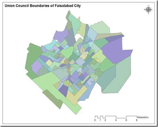
Union Council Boundaries of Faisalabad City

This GIS map consists of polygonal boundaries for 118 union councils of Faisalabad urban area. It has been developed and generously shared by Nasar min Allah Bhalli (M.Phil) from  Department of geography, GC University Faisalabad.

Union council boundaries of faisalabad

                                   .::Click HERE to request for this data set::.

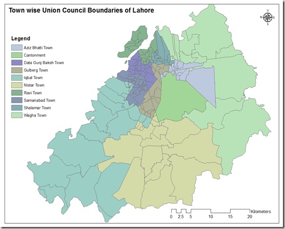
Town wise Union Council Boundaries of Lahore

This GIS map consists of polygonal boundaries for 151 union councils of Lahore urban area divided in 11 Towns.

Union council boundaries of lahore

Special thank to our very Valued Contributor for Lahore.

                                   .::Click HERE to request for this data set::.

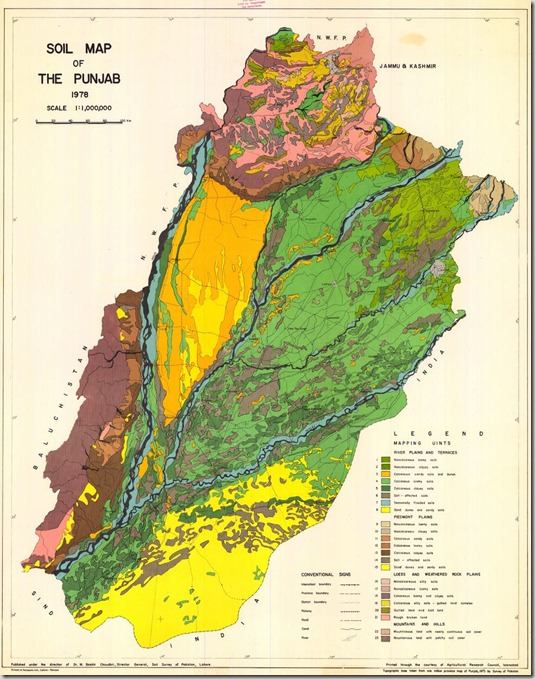
Soil Map of Punjab, Pakistan

Soil_map_punjab

Title:
Soil Map of the Punjab.

Publication year:
1978

Publisher(s):
Direction of Dt. M. Bashir Choudhri. Director General. Soil Survey of Pakistan.

Language:
En

Coordinates:
N34°0 – N27°50 °10 – E75°10

Scale:
1,000,000

Karachi Town Administration Boundaries

This GIS map contains polygonal boundaries for 31 administration town of Karachi. It has been developed by Dr. Jamil H. Kazmi at he Department of geography, University of Karachi and generously shared by Bilal Aslam (Research Fellow).

Karachi_town_boundaries

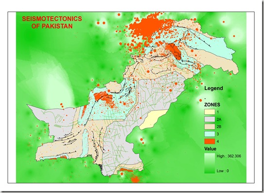
Seismo-Tectonic map of Pakistan

Seismo-Tectonic map of Pakistan having information for earth quack distribution, damages categories and major structural features with the background with interpolation on depth of the earthquakes.

SEISMOTECTONICS

This map has been developed and generously shared by Mohammad Ihsan Afridi, Geologist Pakistan Mineral Development Corporation, Peshawar Pakistan

Base data for this map have been collected from the meteorological department, some from the Engineering council as building design code of Pakistan and the rest have been digitized from the published map of the Geological Survey of Pakistan.

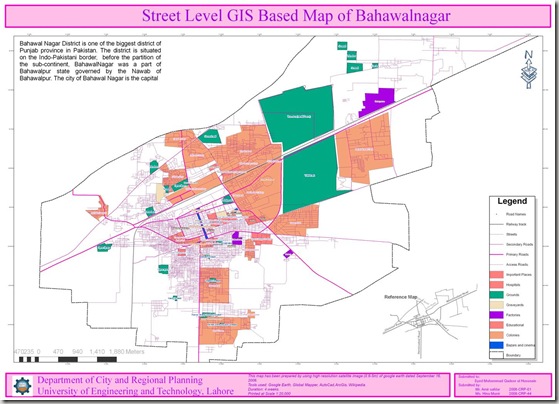
Street Level GIS Map of Bahawalnagar

Bahawalnagar is a city and tehsil of Bahawalnagar District in the Punjab province of Pakistan[1] and lies just south of the Sutlej River, its population according to the 1998 census of Pakistan was 2,061,000[2]. Read More>>
This map has been been prepared by Hina Munir and Amir Safdar. They are Urban Planners from Department of City & Regional Planning, University of Engineering & Technology, Lahore.

Methodology Adopted:

Street level mapping has been completed using high resolution images (0.6-1m) of  Google Earth dating October 26, 2009. Detailed process is mentioned in the tutorial HERE.

Contents:
  1. Data Layers:
  • Primary Roads
  • Secondary Roads
  • Tertiary Roads/ Streets
  • Water Bodies
  • Railway Lines
  • Points of Interest (Hospitals, Educational Buildings, Public Buildings, Mosques, Hotels, Banks, Petrol Pumps etc)
  • Area features (Parks, open spaces, Built up areas, Graveyards, Housing Schemes, water bodies etc)

   2.    Coverage:
  • 77.45 Square Kilometer

Bahawalnagar

Availability:

Data is available in KML and ESRI Shape file formats.

Get Data:
If you want to acquire this data, Use the Request Data Form to share your research and need of this data.

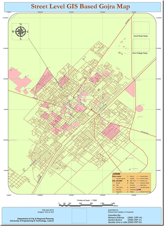
Street Level GIS Map of Gojra

Gojra (Punjabi, Urdu: گوجرہ), the capital of Gojra Tehsil, is a city of Toba Tek Singh District in the Punjab province of Pakistan,[1] it is located at 31°9’N 72°41’E[2] and is located 30 miles (50 km) from Faisalabad, 125 km from Burewala, 157 km from Vehari and 20 miles (32 km) north of Toba Tek Singh.[3] It has a history of more than hundred years, and being the centre of the cultivated lands, the village was famous for its “Mandi” (market) for cash crops. Before the 1947 Partition of India that created Pakistan the “Mandi” was mainly handled by Hindus and Sikhs. Read More>>
This map has been been prepared by Mariyam, Aysha and Syedda Umme Laila. They are Urban Planners from Department of City & Regional Planning, University of Engineering & Technology, Lahore.

Methodology Adopted:

Street level mapping has been completed using high resolution images (0.6-1m) of  Google Earth dating May 20, 2009 within a period of two months. Detailed process is mentioned in the tutorial HERE.

Contents:
  1. Data Layers:
  • Primary Roads
  • Secondary Roads
  • Tertiary Roads/ Streets
  • Water Bodies
  • Railway Lines
  • Points of Interest (Hospitals, Educational Buildings, Public Buildings, Mosques, Hotels, Banks, Petrol Pumps etc)
  • Area features (Parks, open spaces, Built up areas, Graveyards, Housing Schemes, water bodies etc)

   2.    Coverage:

  • 46.58 Square Kilometer

Gojra map2

Availability:

Data is available in KML and ESRI Shape file formats.

Get Data:
If you want to acquire this data, Use the Request Data Form to share your research and need of this data.