“Pakistan (Urdu: پاکستان Pākistān), officially the Islamic Republic of Pakistan, is a country located in South Asia and is at a pivotal location at the crossroads of South Asia, the Middle East, and Central Asia. It has a 1,046 kilometre (650 mile) coastline along the Arabian Sea and Gulf of Oman in the south, and is bordered by Afghanistan and Iran in the west, the Republic of Indiain the east and the People’s Republic of China in the far northeast. Tajikistan also lies adjacent to Pakistan but is separated by the narrow Wakhan Corridor. In recent times, Pakistan has been called part of the Greater Middle East.
Pakistan is the sixth most populous country in the world and has the second largest Muslim population in the world after Indonesia. It also has the second largest Shia Muslim population in the world. The country is listed among the Next Eleven economies, is a founding member of the Organisation of the Islamic Conference, South Asian Association for Regional Cooperation, G20 developing nations, Asia Cooperation Dialogue and the Economic Cooperation Organisation. It is also a member of the United Nations,Commonwealth of Nations, World Trade Organisation, Shanghai Cooperation Organisation, G33 developing countries, Group of 77 developing nations, major non-NATO ally of the United States and is a nuclear state.” Source: Wikipedia
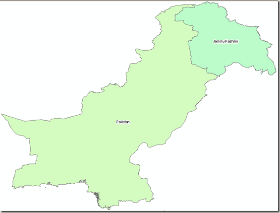
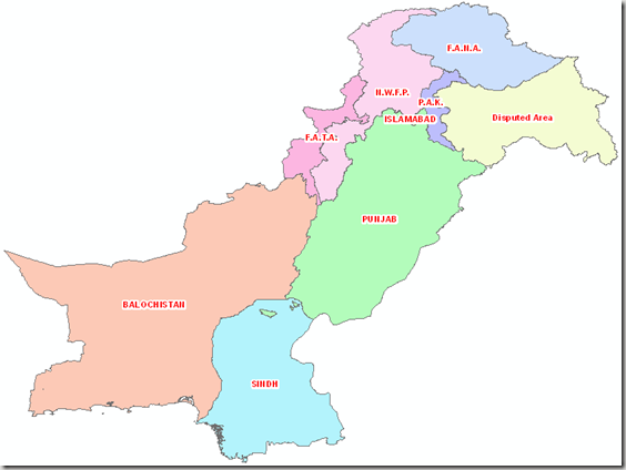
We have collected the GIS maps of various administrative divisions of Pakistan in ESRI Shape file format. Here we present the National and Provincial Boundaries Dataset for free. Please refer back if you modify and update them so that more detailed information can be available for other users.
| Snapshot of Dataset; National Boundaries of Pakistan |
 |
| .::Download Link::. |
“Pakistan is a federation of four provinces, a capital territory and federally administered tribal areas. The government of Pakistan exercises de facto jurisdiction over the western parts of the disputed Kashmir region, organized as two separate political entities (Azad Kashmir and Northern Areas)
Provinces:
Territories:
- Islamabad Capital Territory (IST)
- Federally Administered Tribal Areas (FATA)
- Azad Jammu and Kashmir (or simply Azad Kashmir)(AJK)
- Northern Areas (FANA)
- Balochistan and NWFP also have Provincially Administered Tribal Areas.(PATA)
The third tier of government was composed of 26 divisions with two further tiers (districts and tehsils) administered directly from the provincial level. The divisions were abolished in 2001 and a new three-tiered system of local government came into effect comprising districts, tehsils and union councils with an elected body at each tier. There are currently 107 districts in Pakistan proper, each with several tehsils and union councils. The tribal areas comprise seven tribal agencies and six small frontier regions detached from neighbouring districts whilst Azad Kashmir comprises seven districts and Northern Areas comprises six districts.” Source: Wikipedia
| Snapshot of Dataset; Provincial Boundaries of Pakistan |
 |
| .::Download Link::. |
