Peri Urban Structure Plan of Okara City

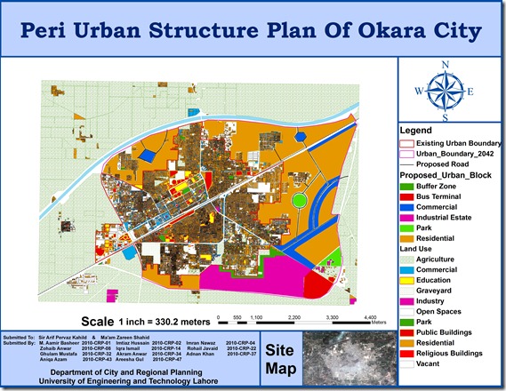
A group of urban planning students from University of Engineering and Technology (CRP-10) including M. Aamir Basheer, Imtiaz Hussain, Imran Nawaz, Zohaib Anwar, Iqra Ismail, Rohail Javaid, Ghulam Mustafa, Akram Anwar, Adnan Khan, Aniqa Azam, Areesha Gul has prepared GIS based peri urban structure plan of Okara City using high resolution satellite image. The map includes Points of interest , Existing urban boundary , Existing land uses, Proposed Roads, and Proposed urban block.

This is a true addition to the existing effort on GIS mapping of Okara which was done by Munawar and Nausheen (CRP-08) in 2009. Previous map can be seen HERE.

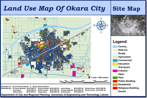
Okara file

Prei Uran final image

Vector Datasets (ESRI Shapefiles)

Currently following vector datasets are available in ESRI Shape files Format at this blog:

Administrative Boundaries Maps:

  1. National and Provincial Boundaries of Pakistan (Admin Level 0 and 1)
  2. District Boundaries of Pakistan (Admin Level 2)
  3. Tehsil Boundaries of Pakistan (Admin Level 3)
  4. Union Council Map (Admin level 4) of District Barkhan – Balochistan
  5. Union Council Map (Admin level 4) of District Jaffarabad – Balochistan

  6. Union Council Map (Admin level 4) of District Killa Saifullah – Balochistan

  7. Union Council Map (Admin level 4) of District Kohlu – Balochistan

  8. Union Council Map (Admin level 4) of District Loralai – Balochistan

  9. Union Council Map (Admin level 4) of District Nasirabad – Balochistan

  10. Union Council Map (Admin level 4) of District Sibi – Balochistan

Khyber Pakhtunkhwa

  1. Union Council Map (Admin level 4) of District Abbottabad – KPK

  2. Union Council Map (Admin level 4) of District Bannu – KPK

  3. Union Council Map (Admin level 4) of District Batagram – KPK

  4. Union Council Map (Admin level 4) of District Buner – KPK

  5. Union Council Map (Admin level 4) of District Charsadda – KPK

  6. Union Council Map (Admin level 4) of District Chitral – KPK

  7. Union Council Map (Admin level 4) of District Dera Ismail Khan – KPK

  8. Union Council Map (Admin level 4) of District Hangu – KPK

  9. Union Council Map (Admin level 4) of District Haripur – KPK

  10. Union Council Map (Admin level 4) of District Karak – KPK

  11. Union Council Map (Admin level 4) of District Kohat – KPK

  12. Union Council Map (Admin level 4) of District Kohistan – KPK

  13. Union Council Map (Admin level 4) of District Lakki Marwat – KPK

  14. Union Council Map (Admin level 4) of District Lower Dir – KPK

  15. Union Council Map (Admin level 4) of District Malakand P.a. – KPK

  16. Union Council Map (Admin level 4) of District Mansehra – KPK

  17. Union Council Map (Admin level 4) of District Mardan – KPK

  18. Union Council Map (Admin level 4) of District Nowshera – KPK

  19. Union Council Map (Admin level 4) of District Peshawar – KPK

  20. Union Council Map (Admin level 4) of District Shangla – KPK

  21. Union Council Map (Admin level 4) of District Swabi – KPK

  22. Union Council Map (Admin level 4) of District Swat – KPK

  23. Union Council Map (Admin level 4) of District Tank – KPK

  24. Union Council Map (Admin level 4) of District Upper Dir – KPK

Punjab

  1. Union Council Map (Admin level 4) of District Bahawalpur – Punjab

  2. Union Council Map (Admin level 4) of District Bhakkar – Punjab

  3. Union Council Map (Admin level 4) of District Dera Ghazi Khan – Punjab

  4. Union Council Map (Admin level 4) of District Jhang – Punjab

  5. Union Council Map (Admin level 4) of District Khushab – Punjab

  6. Union Council Map (Admin level 4) of District Layyah – Punjab

  7. Union Council Map (Admin level 4) of District Mianwali – Punjab

  8. Union Council Map (Admin level 4) of District Multan – Punjab

  9. Union Council Map (Admin level 4) of District Muzaffargarh – Punjab

  10. Union Council Map (Admin level 4) of District Rahim Yar Khan – Punjab

  11. Union Council Map (Admin level 4) of District Rajanpur – Punjab

Sindh

  1. Union Council Map (Admin level 4) of District Dadu – Sindh

  2. Union Council Map (Admin level 4) of District Ghotki – Sindh

  3. Union Council Map (Admin level 4) of District Hyderabad – Sindh

  4. Union Council Map (Admin level 4) of District Jacobabad – Sindh

  5. Union Council Map (Admin level 4) of District Jamshoro – Sindh

  6. Union Council Map (Admin level 4) of District Kashmore – Sindh

  7. Union Council Map (Admin level 4) of District Khairpur – Sindh

  8. Union Council Map (Admin level 4) of District Larkana – Sindh

  9. Union Council Map (Admin level 4) of District Matiari – Sindh

  10. Union Council Map (Admin level 4) of District Naushahro Feroze – Sindh

  11. Union Council Map (Admin level 4) of District Qambar Shahdadkot – Sindh

  12. Union Council Map (Admin level 4) of District Shaheed Benazirabad – Sindh

  13. Union Council Map (Admin level 4) of District Shikarpur – Sindh

  14. Union Council Map (Admin level 4) of District Sukkur – Sindh

  15. Union Council Map (Admin level 4) of District Tando Muhammad Khan – Sindh

  16. Union Council Map (Admin level 4) of District Thatta – Sindh

Urban Union Councils:

Urban Area Maps:

  1. Haripur GIS Map (ESRI Format)
  2. Peshawar GIS Map (ESRI Format)
  3. Mianwali Tehsil GIS Map (ESRI Format)
  4. Quetta GIS Map (ESRI Format)
  5. Gilgit GIS Map (ESRI Format)
  6. Nankana Sahib GIS Map (ESRI Format)
  7. Jaranwala GIS Map (ESRI Format)
  8. Pindi Bhattian GIS Map  (ESRI Format)
  9. Khangah Dogran GIS Map (ESRI Format)
  10. Chiniot GIS Map (ESRI Format)
  11. Chakwal GIS Map (ESRI Format)
  12. Attock GIS based Land use Map (ESRI Format)
  13. Faisalabad GIS based Land use Map (ESRI Format)
  14. Village Kesar Garh (District Kasur) GIS Based Landuse Map (ESRI Format)

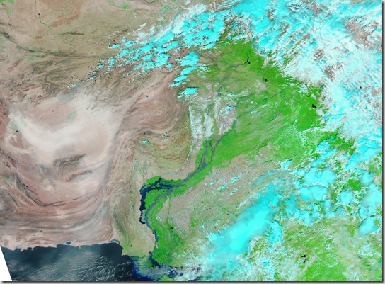
Satellite Image of Pakistan Flood 13 September 2010

Relying on NASA Earth Observatory on Natural Hazards, following image has been geo-referencing and converted to KML:

  1. 13 September 2010

The Moderate Resolution Imaging Spectroradiometer (MODIS) on NASA’s Aqua satellite captured this image of Pakistan. This image uses a combination of infrared and visible light to increase the contrast between water and land. Water appears in varying shades of blue, vegetation is green, and bare ground is pinkish brown. Clouds are bright turquoise.

pakistan_amo_13 Sep 2010

                                          .::Click HERE to request for this data set::.

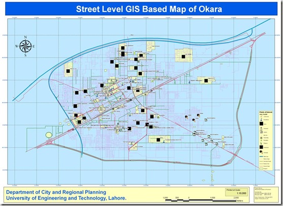
Street Level GIS Map of Okara

Okara Urdu: ( اوکاڑہ) is the capital city of Okara District in the Punjab province of Pakistan.[1] The city is located south-west to the city of Lahore and is famous for its agriculture-based economy and cotton mills. The nearest major city from Okara is Sahiwal (formerly known as Montgomery).
Okara has the largest storage capacity in Asia and is a fairly large district in Pakistan in terms of population. There are famous Pakistan military dairy farms, especially famous for their cheese situated in Okara. These farms are of the Pre-partition or British Indian Era. Mitchels farms also are located in the nearest town Renala Khurd in the Okara District. Read More>>
This street level GIS map has been been prepared by Nausheen and Munawar. They are Urban Planners from Department of City & Regional Planning, University of Engineering & Technology, Lahore.

Methodology Adopted:

Street level mapping has been completed using high resolution images (0.6-1m) of  Google Earth dating July 08, 2009. Detailed process is mentioned in the tutorial HERE.

Contents:
  1. Data Layers:
  • Primary Roads
  • Secondary Roads
  • Tertiary Roads/ Streets
  • Water Bodies
  • Railway Lines
  • Points of Interest (Hospitals, Educational Buildings, Public Buildings, Mosques, Hotels, Banks, Petrol Pumps etc)
  • Area features (Parks, open spaces, Built up areas, Graveyards, Housing Schemes, water bodies etc)

   2.    Coverage:

  • 45 Square Kilometer

Okara

Availability:

Data is available in KML and ESRI Shape file formats.

Get Data:
If you want to acquire this data, Use the Request Data Form to share your research and need of this data.