Mapping of Heritage Sites in Pakistan

With more than 6,000 heritage sites, Pakistan is a country rich in cultural, historical, and archaeological landmarks such as Mohenjo-Daro, Taxila, and the Lahore Fort.

Mapping heritage sites in Pakistan accurately using GIS can facilitate better management, protection, and promotion of the nation’s heritage. It enables authorities to monitor changes in site conditions, assess vulnerabilities to natural and anthropogenic threats like urban expansion or climate impacts, and plan conservation measures effectively. Therefore, Department of Archaeology and Museums, Government of Pakistan has launched and published an online map of the significant heritage sties across all the provinces of Pakistan.

The user can apply filters of Province, district, type and period as well as search the complete heritage sites repository on basis of the site name. On a single click, the user can get detailed information about the site including name, province, district, geographic coordinates, period, relative chronology, description, legal status, year of publication, and bibliographic reference etc.  

GIS also allows integration of visitor data to analyze seasonal trends in tourism, identifying peak and low visitation periods. The presently available visitor record at archeological museums in Pakistan during January to December from 2015 to 2021, published by Pakistan Bureau of Statistics, Government of Pakistan can be geotagged and analyzed. This would help in optimizing visitor management, ensuring that infrastructure and resources are aligned with demand, and enhancing the visitor experience while mitigating over-tourism risks. By leveraging GIS for such purposes, Pakistan can preserve its heritage for future generations while promoting sustainable tourism.

Mapping Minds, Shaping the World #GISDay2024

Today on November 20, 2024, we join global community in celebrating the 25thAnniversary of GIS Day under the theme “Mapping Minds, Shaping the World”. This theme highlights how human creativity and technological advancements come together to transform our world.

Our World by ESRI

We at City Pulse (Pvt.) Ltd. are excited to be part of this global movement. Inspired by the visionary Ralph Nader, who motivated the creation of GIS Day in 1999, we are committed to integrating and building GIS based solutions in key thematic areas of habitat planning, agro-informatics, socio-economic studies, environment, disaster management, water solutions etc. Our goal is to better understand, navigate, and shape communities at rural, urban and regional scale.

Through GIS, we tend to change the traditions, uncover trends, empower informed & smart decision-making and contribute to sustainable development of individuals and communities; our people and the planet, now and into the future.

In line with our efforts, we are also driving the #PakistanGIS initiative—a voluntary movement aimed at building a strong, connected network of GIS professionals, map enthusiasts, students, and researchers. Together, we can innovate, share knowledge, and contribute to society’s growth through the power of geospatial technology.

Current Modes of PakistanGIS: PakistanGISGeonode, PakistanGIS webpage, and Pakistan GIS Facebook Group

Join us on this journey! Let’s connect, innovate, and shape the future world together with GIS.

GIS Service Maps for Municipalities of Punjab Province, Pakistan

GIS Municipal Services Maps serve as powerful tools for enhancing the effectiveness, efficiency, and sustainability of urban governance and service delivery. They enable evidence-based decision-making, promote civic engagement, and contribute to the overall quality of life in cities and municipalities.

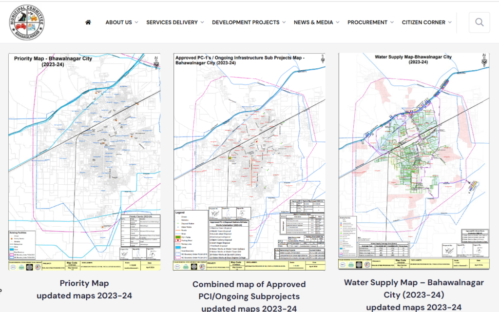
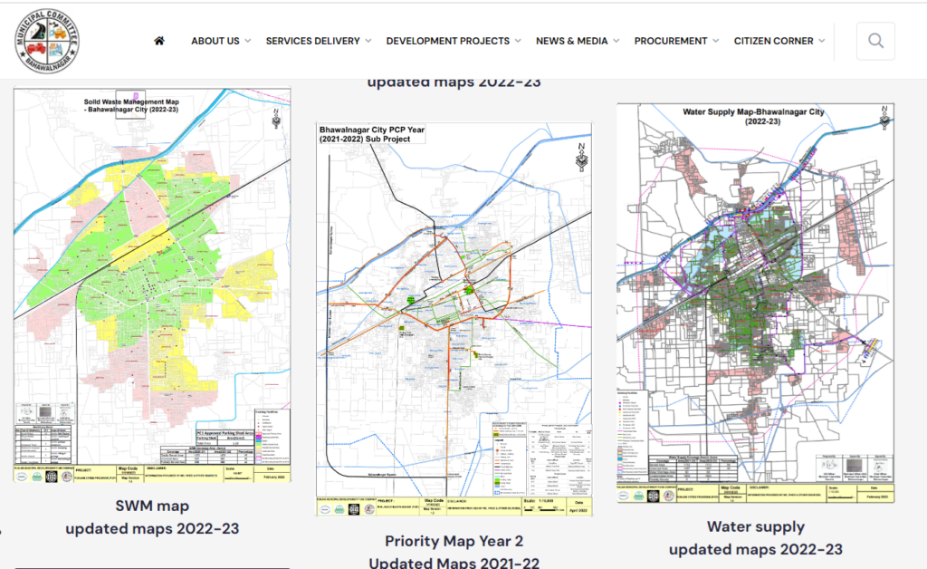
With this realization, Punjab Municipal Development Fund Company (PMDFC), Government of Punjab has harnessed GIS technology to meet their goal “Help Build Healthy Cities”. The GIS-based service maps are regularly developed and disseminated under the Punjab Cities Program (PCP) to support planning officers of 16 municipal corporations/committees within Punjab province namely: Bahawalnagar, Burewala, Daska, Gojra, Hafizabad, Jaranwala, Jhang, Jhelum, Kamalia, Kamoke, Khanewal, KotAddu, Muridke, Okara, Vehari and Wazirabad. Here are few screenshots of the original website:


To date GIS thematic maps including base map, roads and chowks; solid waste management; sewerage; street lights; parks, water supply, approved schemes of these targeted MCs are available online for time period 2023-2024, 2022-2023 and 2021-2022 in pdf format (Source: https://pmdfc.punjab.gov.pk/gis-map-16_cities-pcp).

It is noteworthy that Local Government & Community Development (LG & CD) Department also has representation in Board of Directors (BoDs) of PMDFC.

It’s great to have these detailed maps that cover such diverse thematic nature from connectivity to water works to solid waste management to approved future developments etc. within municipality. However, it would be great if such donor funded projects make the GIS data available in open domain to support researchers and stakeholders. In some cases, there is a significant need to improve the cartographic and vector data quality. PakistanGIS user may use the data as provided. These maps will be available at http://geonode.pakistangis.org/ as well.

QGIS 2.8 is ready for download

qgis2-8_splash

As per the official website of QGIS , updated version QGIS 2.8 has been released and is ready for download in the QGIS  download page.

The Official Changelog for QGIS page says:

This is a special release since it is designated an ‘LTR’ (Long Term Release). It will be supported with backported bug fixes for one year, and will be in permanent feature freeze (i.e. no new features will be added, only bug fixes and trivial updates).

The purpose of this releases is to provide a stable and less frequently changing platform for enterprises and organisations that do not want to deal with updating user skills, training materials etc. more than once per year.

QGIS 2.8 is also a special release because it includes so many great new features, tweaks and enhancements to make the most popular Free desktop GIS even more feature filled and useful.

qgis_icon1

For more detail about new features, visit this link and to download the QGIS 2.8, this is the official download page.

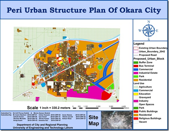
Peri Urban Structure Plan of Okara City

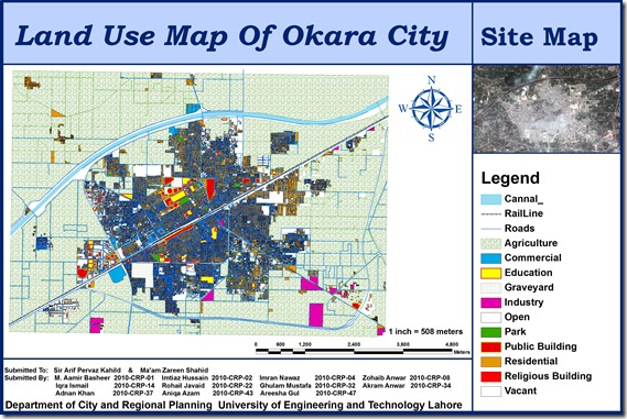
A group of urban planning students from University of Engineering and Technology (CRP-10) including M. Aamir Basheer, Imtiaz Hussain, Imran Nawaz, Zohaib Anwar, Iqra Ismail, Rohail Javaid, Ghulam Mustafa, Akram Anwar, Adnan Khan, Aniqa Azam, Areesha Gul has prepared GIS based peri urban structure plan of Okara City using high resolution satellite image. The map includes Points of interest , Existing urban boundary , Existing land uses, Proposed Roads, and Proposed urban block.

This is a true addition to the existing effort on GIS mapping of Okara which was done by Munawar and Nausheen (CRP-08) in 2009. Previous map can be seen HERE.

Okara file

Prei Uran final image

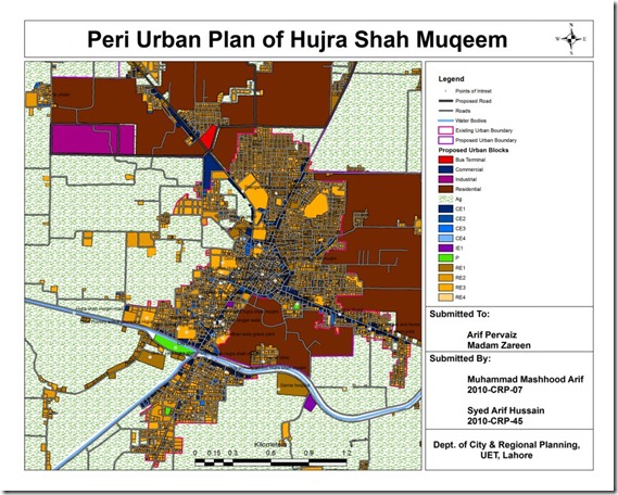
Peri Urban Plan of Hujra Shah Muqeem

An interesting effort by Muhammad Mashhood and Arif Hussain, students at Engineering University, Department of City and Regional Planning.

Its GIS based map of Hujra Shah Muqeem containing base map, existing land uses, road network, points of interest, existing and proposed urban area boundaries, water bodies and proposed land uses for future growth.

pakistangis_hujra_shah_muqeem