About Administrator

--

GIS Map of Lahore (ESRI format)

PKMAPS is a small community of mapping enthusiasts (all over the world) choosing to map Pakistan and share data for free on the internet. They develop maps for GPS or navigators for providing aid in navigation across the Pakistan.

Here, we are using their gps maps to prepare ESRI format shape files, that can be used in GIS software like ArcGIS and Arcview for various analysis and applications for urban planning. Hence expanding the area of application for those maps.

We are presenting a map of Lahore city containing line, point and polygonal features. Coverage and Road hierarchy is visible even from the picture below.image
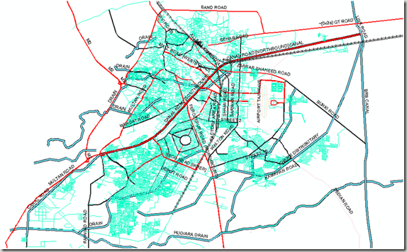


Points Shape File:

About 1082 places of interest are identified and categories as Hospitals, banks, graveyards, libraries, parks, schools, restaurants, shopping centers, stadiums, amusement centers, landmarks and swimming areas etc.

Lines Shape File:

This layer includes 8418 line features which represent arterial roads, collector roads, residential streets, major highways, alleys, railway routes, airport runways, and water streams. 643 features are identified with their names as well.

Polygones Shape File:

This map layer carries 754 polygones showing city parks, lakes, orchards or plantations, housing schemes or institution boundaries and other polygonal features.Location names are updated for 690 features.

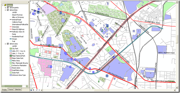
Screen shot below shows a zoom in view where all points, lines and polygonal features can be seen with the level of detail. image


                            .::Special thanks to PKMAPS, smkhan and Faisal::.

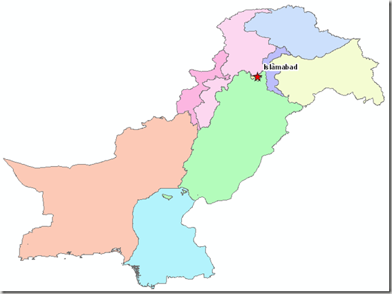
GIS Map of Islamabad/Rawalpindi (ESRI Format)

Islamabad (Meaning “Abode of Islam”) is the capital of Pakistan, and is the tenth largest city in Pakistan. The Rawalpindi/Islamabad metropolitan area is the third largest in Pakistan with a population of over 4.5 million inhabitants, 1,875,000 million in Islamabad and three million in Rawalpindi.

Islamabad is one of the greenest and most well-planned cities of South Asia. The city is well-organized and divided into different sectors and zones. Islamabad is also home to the Faisal Masjid which is well known for its architectural beauty and immense size. Islamabad has been ranked as a Gamma world city, as of 2008”, Read More>>image


Country Pakistan
Territory Islamabad Capital Territory
Constructed 1960s
Union Council 40 UC
Area Total 906.50 km2 (350 sq mi)
Highest elevation 1,604 [1] m (5,263 ft)
Lowest elevation 457 m (1,499 ft)
Population (2009) 1,875,000
Population Density 1,243/km2 (3,219.4/sq mi)
Time zone PST (UTC+5)
Postal Code 44000
Area code(s) 51
Website Islamabad’s Official Website

                              Source:

http://en.wikipedia.org/wiki/Islamabad

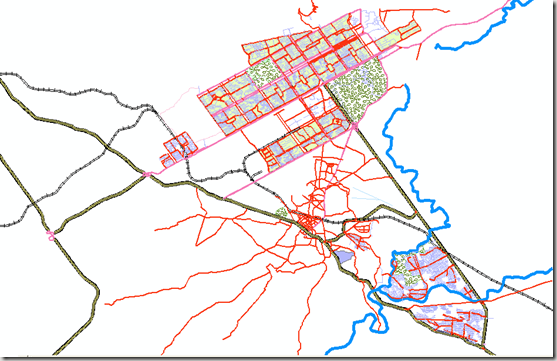
Here, We present a street level GIS map of Islamabad city containing line, point and polygonal features. Coverage and Road hierarchy is visible even from the picture below.

image

Points Shape file:

About 744 places of interest are identified on map by Name and categories according to their use. The details are given in the table below:

Layer Objects
Bank 15
Cemetery 1
Church 79
County 96
Hospital 21
Landmark 2
School 86
Shopping 84
Stadium 5
State 5
Tower 31
Other Point Features 318

Lines Shape file:

This layer includes 4987 line features which represent arterial roads, collector roads, residential streets, major highways, alleys, railway routes, airport runways, and water streams. A summary of these features is given below:

Layer Objects
Airport Runway 2
Alley or Driveway 9
Collector Road 5
Interstate 31
Major Roads/ Highway 76
Railroad, Class 1A 31
Residential Road 4166
River, Unknown Length 5
State Highway 637
Trail 14

Polygones Shape files:

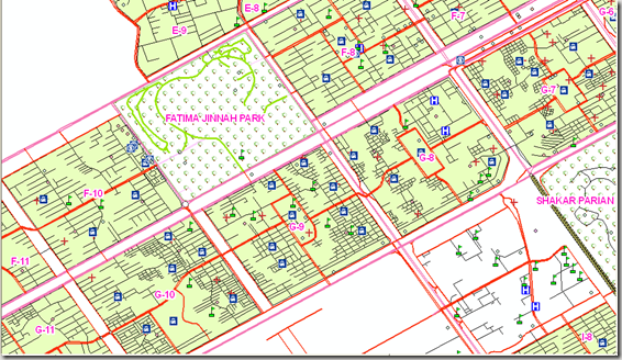
In this shape file, Polygonal features inlcude sectors and small metropolitan areas, lakes and city park.

Screen shot below shows a zoom in view where all points, lines and polygonal features can be seen with the level of detail.image


                              .::Special thanks to PKMAPS and Kifayat Hussain::.

If anyone is interested in Routable Map for Islamabad for GPS devices, Mobiles or Navigators,  have it free from Islamabad Routable Map By PKMAPS.

Satellite Image of Faisalabad

 Faisalabad (Punjabi, Urdu: فیصل آباد) is a city in the province of Punjab, Pakistan. It was formerly known as Lyallpur. Faisalabad is the third largest city in Pakistan after Karachi and Lahore. Before the foundation of the city in 1880, the area was very thinly populated. The population has risen from 9,171 in 1901 to 179,000 in 1951 and to 2,009,000 in 1998.[2] The larger Faisalabad district had a population of about 5.4 million in 1998.[3]

It is an important industrial centre west of Lahore. The city-district of Faisalabad is bound on the north by the districts of Gujranwala andSheikhupura, on the east by Sahiwal, on the south by Toba Tek Singh and on the west by Jhang. It is 1,135 km (705 mi) from Karachi, 128 km (80 mi) from Lahore, 350 km (220 mi) from Islamabad/Rawalpindi, 187 km (116 mi) from Burewala, and 70 km (43 mi) from Jhang.

The city is at a road and railway junction, which has played an influential role in the development of Faisalabad’s trade and economy. The surrounding countryside, irrigated by the Lower Chenab River, has seen expanded production of cotton, wheat, vegetables, and fruits, which form 25% of Pakistan’s exports. The city is also an industrial centre with major railway repair yards, engineering works, and mills thatprocess sugar, flour, and oil seed. Produce includes super phosphates, cotton and silk textiles, hosiery, dyes, agricultural equipment, andghee (clarified butter). Faisalabad is also the site of the prestigious University of Agriculture, founded in 1909.

Faisalabad is the largest industrial city of Pakistan and its textile capital, specialising in export-oriented manufactured goods.” Source: Wikipedia

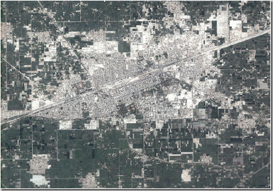
Here is the metadata for the available image. Complete Faisalabad urban area comes in three patches with us. Here is the first patch, rest are coming soon…

DESCRIPTION

Faisalabad.ecw

WEST LONGITUDE

73° 00′ 18.7521" E

NORTH LATITUDE

31° 28′ 51.3489" N

EAST LONGITUDE

73° 09′ 50.3459" E

SOUTH LATITUDE

31° 20′ 32.1941" N

PROJ_DESC

Geographic (Latitude/Longitude) / WGS84 / arc degrees

PROJ_DATUM

WGS84

PROJ_UNITS

arc degrees

EPSG_CODE

4326

COVERED AREA

89.81 sq mi

NUM COLUMNS

29598

NUM ROWS

25847

NUM_BANDS

3

PIXEL WIDTH

0.0000054 arc degrees

PIXEL HEIGHT

0.0000054 arc degrees

BIT_DEPTH

24

PROJ_NAME

GEODETIC

DATUM_NAME

WGS84

TARGET_COMPRESSION

1:10

Screen shot of the Image:

image 

                                    .::Click HERE to request for this data set::.

Satellite Image of Vehari

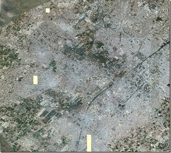
Here is the metadata of the satellite image of Vehari:

DESCRIPTION

vehari.ecw

WEST LONGITUDE

72° 18′ 58.5126" E

NORTH LATITUDE

30° 04′ 3.3672" N

EAST LONGITUDE

72° 23′ 32.4957" E

SOUTH LATITUDE

30° 00′ 53.8632" N

PROJ_DESC

Geographic (Latitude/Longitude) / WGS84 / arc degrees

PROJ_DATUM

WGS84

PROJ_UNITS

arc degrees

EPSG_CODE

4326

COVERED AREA

16.58 sq mi

NUM COLUMNS

11335

NUM ROWS

7840

NUM_BANDS

3

PIXEL WIDTH

0.0000067 arc degrees

PIXEL HEIGHT

0.0000067 arc degrees

BIT_DEPTH

24

PROJ_NAME

GEODETIC

DATUM_NAME

WGS84

TARGET_COMPRESSION

1:10

Screen Shot of the Image:image

                                  .::Click HERE to request for this data set::.

Satellite Image of Liaqatpur (Rahim yar Khan)

Liaquatpur or Liaqatpur is a town and seat of Liaquatpur Tehsil in Rahim Yar Khan District, Pakistan. It is located at 28°55’60N 70°57’0E with an altitude of 95 metres (314 feet).[1]

It is situated exactly between the main cities of Bahawalpur and Rahim Yar Khan. The main railway line connecting Lahore and Karachi passes through this city and a small railway station is also in this city.  (Wikipedia)

Metadata of the satellite image is given below:

DESCRIPTION

Liaqatpur19.ecw

WEST LONGITUDE

70° 55′ 48.2465" E

NORTH LATITUDE

28° 57′ 7.0591" N

EAST LONGITUDE

70° 58′ 9.9187" E

SOUTH LATITUDE

28° 54′ 55.9313" N

PROJ_DESC

Geographic (Latitude/Longitude) / WGS84 / arc degrees

PROJ_DATUM

WGS84

PROJ_UNITS

arc degrees

EPSG_CODE

4326

COVERED AREA

6 sq mi

NUM COLUMNS

7336

NUM ROWS

6790

NUM_BANDS

3

PIXEL WIDTH

0.0000054 arc degrees

PIXEL HEIGHT

0.0000054 arc degrees

BIT_DEPTH

24

PROJ_NAME

GEODETIC

DATUM_NAME

WGS84

TARGET_COMPRESSION

1:10

Screen Shot of Image:

clip_image002[4]

                                      .::Click HERE to request for this data set::.

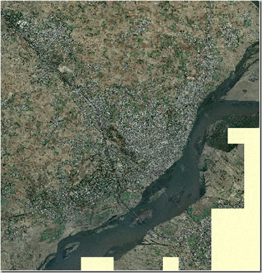
Satellite Image of Jhelum City

Below is the metadata of the image of Jhelum city available here:

DESCRIPTION

Jhelum19.ecw

Image Date

June 2009

WEST LONGITUDE

73° 40′ 5.3124" E

NORTH LATITUDE

32° 59′ 55.0067" N

EAST LONGITUDE

73° 46′ 13.3587" E

SOUTH LATITUDE

32° 53′ 24.5972" N

PROJ_DESC

Geographic (Latitude/Longitude) / WGS84 / arc degrees

PROJ_DATUM

WGS84

PROJ_UNITS

arc degrees

EPSG_CODE

4326

COVERED AREA

44.47 sq mi

NUM COLUMNS

19058

NUM ROWS

20216

NUM_BANDS

3

PIXEL WIDTH

0.0000054 arc degrees

PIXEL HEIGHT

0.0000054 arc degrees

BIT_DEPTH

24

PROJ_NAME

GEODETIC

DATUM_NAME

WGS84

TARGET_COMPRESSION

1:29

Screen Shot of Image:image

                           .::Click HERE to request for this data set::.

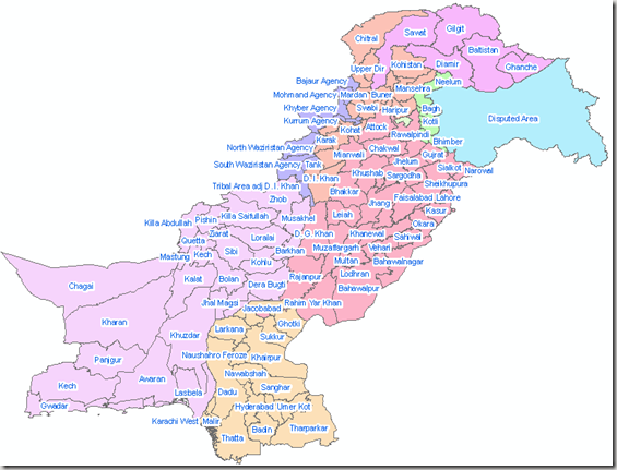
District Boundaries of Pakistan

“The Districts of Pakistan are the second order administrative divisions of Pakistan. Districts were the third order of administrative divisions, below provinces and “divisions“, until the reforms of August 2000, when “divisions” were abolished. Districts now form the top tier of a three-tier system of local government with the two lower tiers composed of approximately 400 tehsils and more than six thousand union councils.
Prior to 2001, there were 106 districts but with the reorganisation, these were reduced to 102 by the merger of the five districts of Karachi Central, Karachi East, Karachi South, Karachi West and Malir to form Karachi District. The five districts had formed the division of Karachi which was abolished. The number of districts rose to 106 again in December 2004, when four new districts were created in the province of Sindh of which one (Umerkot) had existed until 2000 and three districts (Kashmore, Qambar and Jamshoro) were newly created.
In May 2005, the Punjab provincial government created a new district[2] by raising the status of Nankana Sahib from a tehsil of Sheikhpura District to a district in its own right.
In Azad Kashmir, the second tier of government is formed by two administrative divisions (Muzaffarabad) & (Mirpur) with a third tier of eight districts. In the Northern Areas, there are six districts divided between two regions of Gilgit and Baltistan; Baltistan being the part of Ladakh in Pakistani control.” Source: Wikipedia
An overview of data is given in table below:

Subdivision
Number of districts
Balochistan Province
27
North-West Frontier Province 24
Punjab Province 36
Sindh Province 23
Islamabad Capital Territory 1
Federally Administered Tribal Areas 7 tribal agencies plus 6 frontier regions
Azad Kashmir 8
Northern Areas 6
Pakistan 128 districts plus 7 tribal agencies

Snapshot of Dataset; District Boundaries of Pakistan
image
                                          .::Click HERE to request for this data set::.

Tehsil Boundaries of Pakistan

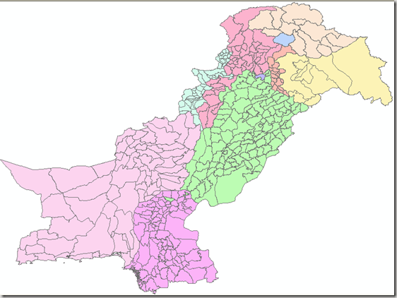
Here we present the Tehsil Boundaries Dataset which is third level administration boundaries in Pakistan.
A summary of data is given below in the table:

Subdivision Name Tehsils
Balochistan 62
Disputed Area 10
F.A.N.A 13
F.A.T.A. 48
Islamabad 1
N.W.F.P. 44
P.A.K. 18
Punjab 119
Sindh 89
Total 404

Snapshot of Dataset; Tehsil Boundaries of Pakistan
image
                                  
                                           .::Click HERE to request for this data set::.

National & Provincial Boundaries of Pakistan

Pakistan (Urdu: پاکستان Pākistān), officially the Islamic Republic of Pakistan, is a country located in South Asia and is at a pivotal location at the crossroads of South Asia, the Middle East, and Central Asia. It has a 1,046 kilometre (650 mile) coastline along the Arabian Sea and Gulf of Oman in the south, and is bordered by Afghanistan and Iran in the west, the Republic of Indiain the east and the People’s Republic of China in the far northeast. Tajikistan also lies adjacent to Pakistan but is separated by the narrow Wakhan Corridor. In recent times, Pakistan has been called part of the Greater Middle East.

Pakistan is the sixth most populous country in the world and has the second largest Muslim population in the world after Indonesia. It also has the second largest Shia Muslim population in the world. The country is listed among the Next Eleven economies, is a founding member of the Organisation of the Islamic Conference, South Asian Association for Regional Cooperation, G20 developing nations, Asia Cooperation Dialogue and the Economic Cooperation Organisation. It is also a member of the United Nations,Commonwealth of Nations, World Trade Organisation, Shanghai Cooperation Organisation, G33 developing countries, Group of 77 developing nations, major non-NATO ally of the United States and is a nuclear state.Source: Wikipedia

We have collected the GIS maps of various administrative divisions of Pakistan in ESRI Shape file format. Here we present the National and Provincial Boundaries Dataset for free. Please refer back if you modify and update them so that more detailed information can be available for other users.


Snapshot of Dataset; National Boundaries of Pakistan
image
                                                      .::Download Link::.


Pakistan is a federation of four provinces, a capital territory and federally administered tribal areas. The government of Pakistan exercises de facto jurisdiction over the western parts of the disputed Kashmir region, organized as two separate political entities (Azad Kashmir and Northern Areas)

Provinces:

  1. Balochistan
  2. North-West Frontier Province (NWFP)
  3. Punjab
  4. Sindh

Territories:

  1. Islamabad Capital Territory (IST)
  2. Federally Administered Tribal Areas (FATA)
  3. Azad Jammu and Kashmir (or simply Azad Kashmir)(AJK)
  4. Northern Areas (FANA)

The third tier of government was composed of 26 divisions with two further tiers (districts and tehsils) administered directly from the provincial level. The divisions were abolished in 2001 and a new three-tiered system of local government came into effect comprising districts, tehsils and union councils with an elected body at each tier. There are currently 107 districts in Pakistan proper, each with several tehsils and union councils. The tribal areas comprise seven tribal agencies and six small frontier regions detached from neighbouring districts whilst Azad Kashmir comprises seven districts and Northern Areas comprises six districts.Source: Wikipedia

Snapshot of Dataset; Provincial Boundaries of Pakistan
image
                                                      .::Download Link::.

Satellite Image of Lahore

Satellite image of Lahore at good resolution is available at PKMaps. These can be used for any GIS/RS assignment and analysis.

Source of quoted material: http://pkmaps.freeforums.org/lahore-satellite-imagery-at-18x-zoom-t31.html

You can find all the Yahoo imagery you need for mapping Lahore at 18x zoom level at the following RapidShare download link:

http://rapidshare.com/files/176314336/lahore_yahoo_satalite_1.zip
http://rapidshare.com/files/176316142/lahore_yahoo_satalite_2.zip
http://rapidshare.com/files/176317579/lahore_yahoo_satalite_3.zip
http://rapidshare.com/files/176320007/lahore_yahoo_satalite_4.zip
http://rapidshare.com/files/176322298/lahore_yahoo_satalite_5.zip
http://rapidshare.com/files/176321238/lahore_yahoo_satalite_6.zip
http://rapidshare.com/files/176324063/lahore_yahoo_satalite_7.zip
http://rapidshare.com/files/176325590/lahore_yahoo_satalite_8.zip
http://rapidshare.com/files/176324388/lahore_yahoo_satalite_9.zip

These zips contain the Ozi Explorer .map files and embeded merged images in jpeg format.
They have been downloaded from Yahoo using gMapMaker.
There are 9 files in total so that Lahore can be split up into 9 portions.
You can use these Ozi map files along with their image files in GPSMapEdit for your mapping.
Depending on where you unzip the file contects you may need to edit with a text editor the .jpg file path on 3rd line in each .map (Ozi Explorer file) to point to the right location of its associated .jpg file for the .map file to work.
The original jpeg tiles from Yahoo at 18x zoom downloaded by gMapMaker can be found at the following rapishare links:

http://rapidshare.com/files/176831705/yahoo_satallite_imagery_at_18x.part1.rar
http://rapidshare.com/files/176833586/yahoo_satallite_imagery_at_18x.part2.rar
http://rapidshare.com/files/176834619/yahoo_satallite_imagery_at_18x.part3.rar

PS: You will need to download all these .rar files and run winrar to extract them to one folder.
Mobile GMaps can users also benifit from these files.