WebGIS Expert Required in Islamabad (17 June 2011)

The Federal Institute for Geosciences and Natural Resources is looking for an WebGIS expert in Islamabad.

Knowledge & Skills:

1. Master in GIS or Computer Science
2. Excellent ArcGIS Skills
3. CMS skills
4. WebGIS/Webmapping skills and WebGIS project references
5. Good communication skills, in English

Applications are invited with following details:
List of recent GIS and WebGIS related jobs performed, availability during next 1 month
Contact Information

Send your applications to ingo.hoelzle@bgr.de as early as possible.

Note: This information has been shared by Ingo Hoelzle through a comment HERE. PakGIS is not responsible for any dealings between applicant and employer. We are sharing information about availability of jobs or openings in different organization so that others may benefit from that.

GIS Map of Lahore (ESRI format)

PKMAPS is a small community of mapping enthusiasts (all over the world) choosing to map Pakistan and share data for free on the internet. They develop maps for GPS or navigators for providing aid in navigation across the Pakistan.

Here, we are using their gps maps to prepare ESRI format shape files, that can be used in GIS software like ArcGIS and Arcview for various analysis and applications for urban planning. Hence expanding the area of application for those maps.

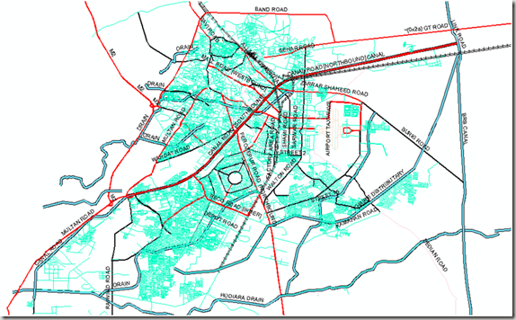
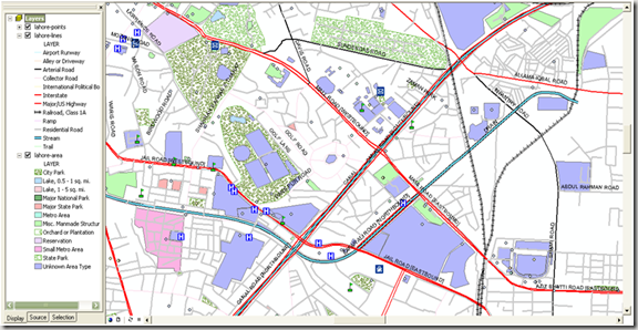
We are presenting a map of Lahore city containing line, point and polygonal features. Coverage and Road hierarchy is visible even from the picture below.image


Points Shape File:

About 1082 places of interest are identified and categories as Hospitals, banks, graveyards, libraries, parks, schools, restaurants, shopping centers, stadiums, amusement centers, landmarks and swimming areas etc.

Lines Shape File:

This layer includes 8418 line features which represent arterial roads, collector roads, residential streets, major highways, alleys, railway routes, airport runways, and water streams. 643 features are identified with their names as well.

Polygones Shape File:

This map layer carries 754 polygones showing city parks, lakes, orchards or plantations, housing schemes or institution boundaries and other polygonal features.Location names are updated for 690 features.

Screen shot below shows a zoom in view where all points, lines and polygonal features can be seen with the level of detail. image


                            .::Special thanks to PKMAPS, smkhan and Faisal::.

GIS Map of Islamabad/Rawalpindi (ESRI Format)

Islamabad (Meaning “Abode of Islam”) is the capital of Pakistan, and is the tenth largest city in Pakistan. The Rawalpindi/Islamabad metropolitan area is the third largest in Pakistan with a population of over 4.5 million inhabitants, 1,875,000 million in Islamabad and three million in Rawalpindi.

Islamabad is one of the greenest and most well-planned cities of South Asia. The city is well-organized and divided into different sectors and zones. Islamabad is also home to the Faisal Masjid which is well known for its architectural beauty and immense size. Islamabad has been ranked as a Gamma world city, as of 2008”, Read More>>image


Country Pakistan
Territory Islamabad Capital Territory
Constructed 1960s
Union Council 40 UC
Area Total 906.50 km2 (350 sq mi)
Highest elevation 1,604 [1] m (5,263 ft)
Lowest elevation 457 m (1,499 ft)
Population (2009) 1,875,000
Population Density 1,243/km2 (3,219.4/sq mi)
Time zone PST (UTC+5)
Postal Code 44000
Area code(s) 51
Website Islamabad’s Official Website

                              Source:

http://en.wikipedia.org/wiki/Islamabad

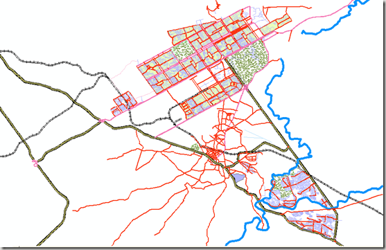
Here, We present a street level GIS map of Islamabad city containing line, point and polygonal features. Coverage and Road hierarchy is visible even from the picture below.

image

Points Shape file:

About 744 places of interest are identified on map by Name and categories according to their use. The details are given in the table below:

Layer Objects
Bank 15
Cemetery 1
Church 79
County 96
Hospital 21
Landmark 2
School 86
Shopping 84
Stadium 5
State 5
Tower 31
Other Point Features 318

Lines Shape file:

This layer includes 4987 line features which represent arterial roads, collector roads, residential streets, major highways, alleys, railway routes, airport runways, and water streams. A summary of these features is given below:

Layer Objects
Airport Runway 2
Alley or Driveway 9
Collector Road 5
Interstate 31
Major Roads/ Highway 76
Railroad, Class 1A 31
Residential Road 4166
River, Unknown Length 5
State Highway 637
Trail 14

Polygones Shape files:

In this shape file, Polygonal features inlcude sectors and small metropolitan areas, lakes and city park.

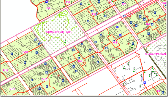
Screen shot below shows a zoom in view where all points, lines and polygonal features can be seen with the level of detail.image


                              .::Special thanks to PKMAPS and Kifayat Hussain::.

If anyone is interested in Routable Map for Islamabad for GPS devices, Mobiles or Navigators,  have it free from Islamabad Routable Map By PKMAPS.