About Administrator

--

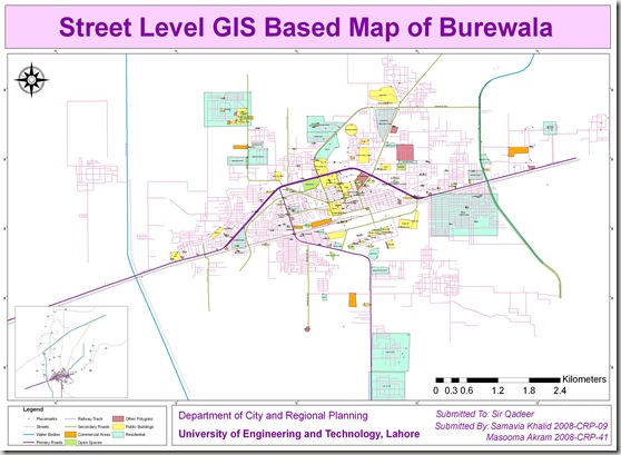
Street Level GIS Map of Burewala

Burewala (Urdu: بورے والا) is a city of Vehari District in southern Punjab, Pakistan. It is located at 30°10’0N 72°39’0E and has an altitude of 133 metres (439 feet).[1]  It is the 30th biggest city in Pakistan by population.[3] The city of Burewala is the headquarters of Burewala Tehsil, an administrative subdivision of the district.[4] It is located 1035 km away from Karachi, 187 km from Faisalabad, 208 km from Lahore, 135 km from Multan, 35 km from Vehari. 40 km from Arifwala,75 km from Pakpattan and 103 km from Bahawalpur. Read More>>
This GIS map has been been prepared by Samavia Khalid and Masooma Ikram under our supervision. They are Urban Planners from Department of City & Regional Planning, University of Engineering & Technology, Lahore.

Methodology Adopted:

Street level mapping has been completed using high resolution images (0.6-1m) from  Google Earth dating September 26, 2009. Detailed process is mentioned in the tutorial HERE.

Contents:
  1. Data Layers:
  • Primary Roads
  • Secondary Roads
  • Tertiary Roads/ Streets
  • Water Bodies
  • Railway Lines
  • Points of Interest (Hospitals, Educational Buildings, Public Buildings, Mosques etc)
  • Area features (Parks, open spaces, Built up areas etc)

   2.    Coverage:

  • 308 Square Kilometer

Burewala GIS

Availability:

Data is available in KML and ESRI Shape file formats.

Get Data:
If you want to acquire this data, use the Request Data Form to share your research and need of this data.

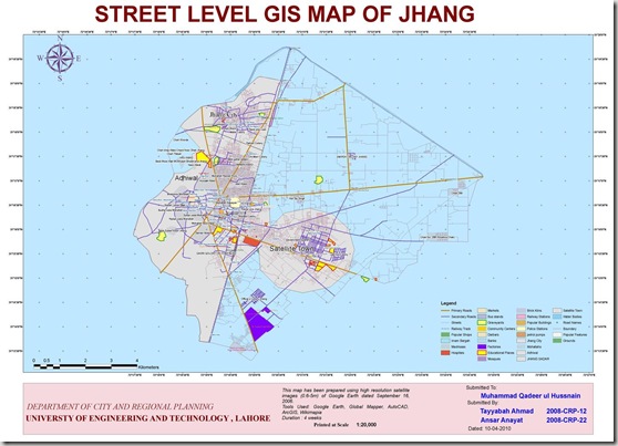
Street Level GIS Map of Jhang

Jhang (Punjabi, Urdu: جھنگ) is the principal city of Jhang District in the Punjab province of Pakistan. It is situated on the east bank of theChenab river at a latitude of 31.15° N and longitude of 72.22°E[1]. Read More>>

This GIS map has been been prepared by Tayyabah Ahmad and Ansar Inayat under our supervision. They are Urban Planners from Department of City & Regional Planning, University of Engineering & Technology, Lahore.

Methodology Adopted:

Street level mapping has been completed using high resolution images (0.6-1m) from  Google Earth dating September 16, 2006. Detailed process is mentioned in the tutorial HERE.

Contents:
  1. Data Layers:
  • Primary Roads
  • Secondary Roads
  • Tertiary Roads/ Streets
  • Water Bodies
  • Railway Lines
  • Points of Interest (Hospitals, Educational Buildings, Public Buildings, Mosques etc)
  • Area features (Parks, open spaces, Built up areas etc)

   2.    Coverage:

  • 118.05 Square Kilometer

Jhang Final

Availability:

Data is available in KML and ESRI Shape file formats.
Get Data:

If you want to acquire this data, use the Request Data Form to share your research and need of this data.

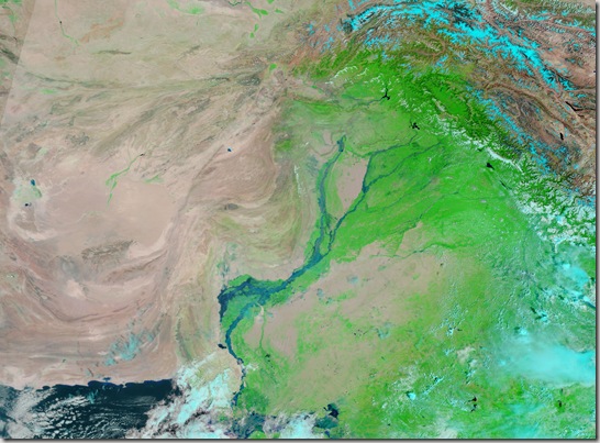
Satellite Image Pakistan Flood 29 August 2010

Relying on NASA Earth Observatory on Natural Hazards, following image has been geo-referencing and converted to KML:

  1. 29 August 2010

The Moderate Resolution Imaging Spectroradiometer (MODIS) on NASA’sAqua satellite captured this image of Pakistan. This image uses a combination of infrared and visible light to increase the contrast between water and land. Water appears in varying shades of blue, vegetation is green, and bare ground is pinkish brown. Clouds are bright turquoise.

pakistan_tmo_29 Aug 2010

                                          .::Click HERE to request for this data set::.

GIS Digitizers Required

  • Job Location: Islamabad
  • Country: Pakistan
  • Positions: 2
  • Job Type: Contractual (Short Term 10-15 Days)
  • Department: GIS
  • Last Date: 13 March, 2011

Education, Knowledge, Skills, Abilities

  1. B.A, BSc with GIS Skills acquired through GIS degree or short courses
  2. Previous experience in  Image digitization using ArcGIS (at least for 1 year). Experience in extracting/ developing base layers from satellite images (Natural Color LandSAT) will be an added advantage.
  3. Should be able to perform data management functions in ArcGIS, such as developing layers, managing data attributes, shape files management etc.

  4. Must have experience of cleaning polygonal files, removing sliver polygons and other digitizing errors

  5. Good communication skills, in English

Applications are invited with following details;

  1. List of recent GIS related jobs performed, details of digitizing tasks and availability during next 1 month

Contact Information

Send your applications to by latest 13th March, 2011

GIS Job in Benazir Income Support Program(BISP) 13 May 2011

Dear All,

Benazeer Income Support Program is looking for a GIS person.

Project Duration is 4 Years
Project is in collaboration with the World Bank.

If you are interested, Please E-mail your CVs to afaruq@gmail.com as soon as possible.

Note: This information has been shared by Nizam ud Din at our facebook page HERE and by Hafsa Firdous here at This Page

GIS Jobs in Urban Unit Lahore (2011)

Dear All,

The Urban Unit, Lahore  is looking for high quality, GIS professionals, including Developers, Web developers, hardware support and digitizers.

If any of you is interested or know someone else who is suitable for the work, please encourage them to e-mail their CVs directly to the Project Director UU (nasir_dsp@yahoo.com) as early as possible.

Note: This information has been shared by Nizam ud Din at our facebook page HERE.

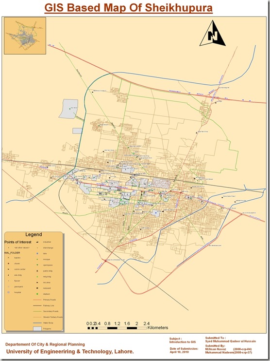
Street Level GIS Map of Sheikhupura

This map has been been prepared by Ihsan Nawaz and Muhammad Nadeem under our supervision. They are Urban Planners from Department of City & Regional Planning, University of Engineering & Technology, Lahore.

Methodology Adopted:

Street level mapping has been completed using high resolution images (0.6-1m) from  Google Earth dating October 12, 2009. Detailed process is mentioned in the tutorial HERE.

Contents:
  1. Data Layers:
  • Primary Roads
  • Secondary Roads
  • Tertiary Roads/ Streets
  • Water Bodies
  • Railway Lines
  • Points of Interest (Hospitals, Educational Buildings, Public Buildings, Mosques etc)
  • Area features (Parks, open spaces, Built up areas etc)

   2.    Coverage:

  • 115.70 Square Kilometer

Sheikhupura GIS

Availability:

Data is available in KML and ESRI Shape file formats.
Get Data:
If you want to acquire this data, use the Request Data Form to share your research and need of this data.

Street Level GIS Map of Sahiwal

Sahiwal (Punjabi, Urdu: ساہیوال) is a city in Punjab, Pakistan. It is the administrative centre of Sahiwal District and Sahiwal Division.The districts of Okara and Pakpattan are under Sahiwal division. Sahiwal lies approximately 180 km from the major city of Lahore. And it is the biggest city between Lahore and Multan. Sahiwal District is included in the former Multan Division and lies between 30-39 north latitude and 73-06 longitude. The city lies in the densely populated region between the Sutlej and Ravi rivers. Irrigation in the region is provided by the Bari Doab Canal system. The principal crops are wheat, cotton, tobacco, legumes, and oilseeds. Cotton goods and lacquered woodwork are manufactured. About 18 miles Southwest of Sahiwal is Harappa, an ancient city of the world, oldest urban center of Harappan or Indus civilization in South Asia. About 28 miles (45 km) west of Sahiwal, at Kamalia, is the site of a Malli city captured by Alexander the Great in 325 bc. Pop. (1998) city, 207,388. The people of Sahiwal are known as Sahiwalians. This city got his name from the first inhibitors of this city the sahis (a jutt sub-tribe or cast). Sahiwal was named as Montgomery city before 1966. In 1966 a famous legendary politician Mufti Zia-ul-Hasan changed its name to Sahiwal. Read More>>
This map has been been prepared by Muhammad Umair and Hassan Ali. They are Urban Planners from Department of City & Regional Planning, University of Engineering & Technology, Lahore.

Methodology Adopted:

Street level mapping has been completed using high resolution images (0.6-1m) of  Google Earth dating August 24, 2006 within a period of two months. Detailed process is mentioned in the tutorial HERE.

Contents:
  1. Data Layers:
  • Primary Roads
  • Secondary Roads
  • Tertiary Roads/ Streets
  • Water Bodies
  • Railway Lines
  • Points of Interest (Hospitals, Educational Buildings, Public Buildings, Mosques, Hotels, Banks, Petrol Pumps etc)
  • Area features (Parks, open spaces, Built up areas, Graveyards, Housing Schemes, water bodies etc)

   2.    Coverage:

  • 70 Square Kilometer

Sahiwal1

Availability:

Data is available in KML and ESRI Shape file formats.

Get Data:
If you want to acquire this data, Use the Request Data Form to share your research and need of this data.

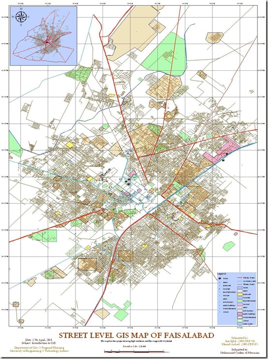
Street Level GIS Map of Faisalabad

Faisalabad (Punjabi, Urdu: فیصل آباد) is a city in the province of Punjab, Pakistan. It  is the third largest city in Pakistan after Karachi and Lahore.
It is an important industrial centre west of Lahore. The city-district of Faisalabad is bound on the north by the districts of Gujranwala and Sheikhupura, on the east by Sahiwal, on the south by Toba Tek Singh and on the west by Jhang. It is 1,135 km (705 mi) from Karachi, 128 km (80 mi) from Lahore, 350 km (220 mi) from Islamabad/Rawalpindi, 187 km (116 mi) from Burewala, and 70 km (43 mi) from Jhang. “Source: Wikipedia” Read More>>
This Street level GIS map has been been prepared by Hamid Arshad and Ijaz Iqbal. They are Urban Planners from Department of City & Regional Planning, University of Engineering & Technology, Lahore.

Methodology Adopted:

Street level mapping has been completed using high resolution images (0.6-1m) of  Google Earth dating December 25, 2005 within a period of two months. Detailed process is mentioned in the tutorial HERE.

Contents:
  1. Data Layers:
  • Primary Roads
  • Secondary Roads
  • Tertiary Roads/ Streets
  • Water Bodies
  • Railway Lines
  • Points of Interest (Hospitals, Educational Buildings, Public Buildings, Mosques, Hotels, Banks, Petrol Pumps etc)
  • Area features (Parks, open spaces, Built up areas, Graveyards, Housing Schemes, water bodies etc)

   2.    Coverage:

  • 717 Square Kilometer

Faisalabad1

Availability:

Data is available in KML and ESRI Shape file formats.
Get Data:
If you want to acquire this data, Use the Request Data Form to share your research and need of this data.