This GIS map contains polygonal boundaries for 31 administration town of Karachi. It has been developed by Dr. Jamil H. Kazmi at he Department of geography, University of Karachi and generously shared by Bilal Aslam (Research Fellow).
Category Archives: GIS Vector Data
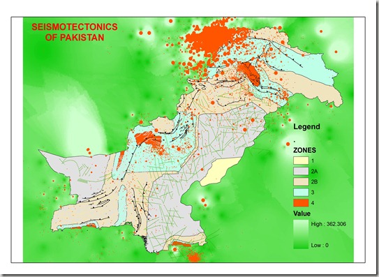
Seismo-Tectonic map of Pakistan
Seismo-Tectonic map of Pakistan having information for earth quack distribution, damages categories and major structural features with the background with interpolation on depth of the earthquakes.
This map has been developed and generously shared by Mohammad Ihsan Afridi, Geologist Pakistan Mineral Development Corporation, Peshawar Pakistan
Base data for this map have been collected from the meteorological department, some from the Engineering council as building design code of Pakistan and the rest have been digitized from the published map of the Geological Survey of Pakistan.
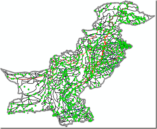
Road Network and Settlements of Pakistan
Here is the Major Road Network of whole Pakistan along with the location of 69211 populated places. This dataset is prepared from a routable GPS map prepared by Ben and converted into ESRI shape files for ArcGIS users.
Original source in polish map format is available at THIS LINK at MapCentre2.
Below are some glimpses of the coverage of dataset.
.
Get Data:
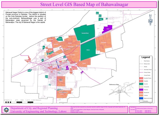
Street Level GIS Map of Bahawalnagar
Bahawalnagar is a city and tehsil of Bahawalnagar District in the Punjab province of Pakistan[1] and lies just south of the Sutlej River, its population according to the 1998 census of Pakistan was 2,061,000[2]. Read More>>
This map has been been prepared by Hina Munir and Amir Safdar. They are Urban Planners from Department of City & Regional Planning, University of Engineering & Technology, Lahore.
Methodology Adopted:
Street level mapping has been completed using high resolution images (0.6-1m) of Google Earth dating October 26, 2009. Detailed process is mentioned in the tutorial HERE.
Contents:
- Data Layers:
- Primary Roads
- Secondary Roads
- Tertiary Roads/ Streets
- Water Bodies
- Railway Lines
- Points of Interest (Hospitals, Educational Buildings, Public Buildings, Mosques, Hotels, Banks, Petrol Pumps etc)
-
Area features (Parks, open spaces, Built up areas, Graveyards, Housing Schemes, water bodies etc)
2. Coverage:
- 77.45 Square Kilometer
Availability:
Data is available in KML and ESRI Shape file formats.
Get Data:
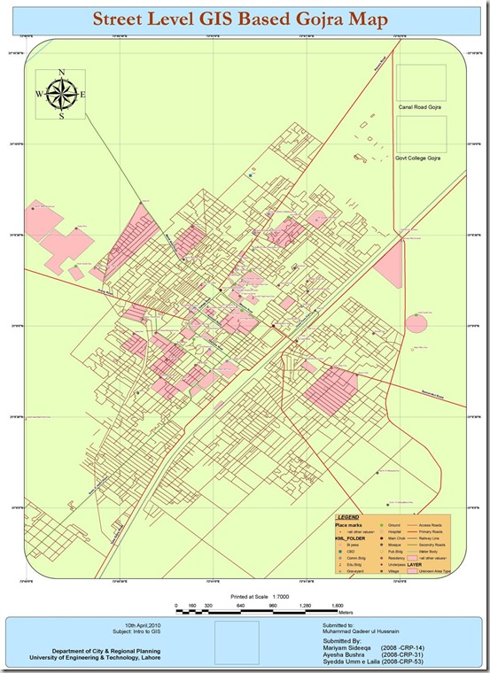
Street Level GIS Map of Gojra
Gojra (Punjabi, Urdu: گوجرہ), the capital of Gojra Tehsil, is a city of Toba Tek Singh District in the Punjab province of Pakistan,[1] it is located at 31°9’N 72°41’E[2] and is located 30 miles (50 km) from Faisalabad, 125 km from Burewala, 157 km from Vehari and 20 miles (32 km) north of Toba Tek Singh.[3] It has a history of more than hundred years, and being the centre of the cultivated lands, the village was famous for its “Mandi” (market) for cash crops. Before the 1947 Partition of India that created Pakistan the “Mandi” was mainly handled by Hindus and Sikhs. Read More>>
This map has been been prepared by Mariyam, Aysha and Syedda Umme Laila. They are Urban Planners from Department of City & Regional Planning, University of Engineering & Technology, Lahore.
Methodology Adopted:
Street level mapping has been completed using high resolution images (0.6-1m) of Google Earth dating May 20, 2009 within a period of two months. Detailed process is mentioned in the tutorial HERE.
Contents:
- Data Layers:
- Primary Roads
- Secondary Roads
- Tertiary Roads/ Streets
- Water Bodies
- Railway Lines
- Points of Interest (Hospitals, Educational Buildings, Public Buildings, Mosques, Hotels, Banks, Petrol Pumps etc)
-
Area features (Parks, open spaces, Built up areas, Graveyards, Housing Schemes, water bodies etc)
2. Coverage:
- 46.58 Square Kilometer
Availability:
Data is available in KML and ESRI Shape file formats.
Get Data:
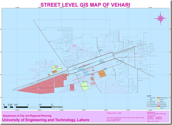
Street Level GIS Map of Vehari
Vehari (Urdu: وہاڑی) is a city in the Punjab province of Pakistan. The city, which is the capital of the district and tehsil of the same name[4], is located at 30°1’0N 72°21’0E at an altitude of 135m (446ft)[5] and lies about 100 kilometres from the regional metropolis of Multan and about 25 kilometres north of the river Sutlej – the southernmost of the five rivers of the Punjab region. A headworks of canals is located on this river near Luddan on the Luddan-Vehari canal providing irrigation water to both banks of the river, which includes the upper fringes of theCholistan Desert. Read More>>
This map has been been prepared by Irsa Afzal and Iqra Yousaf. They are Urban Planners from Department of City & Regional Planning, University of Engineering & Technology, Lahore.
Methodology Adopted:
Street level mapping has been completed using high resolution images (0.6-1m) of Google Earth dating May 20, 2009 within a period of two months. Detailed process is mentioned in the tutorial HERE.
Contents:
- Data Layers:
- Primary Roads
- Secondary Roads
- Tertiary Roads/ Streets
- Water Bodies
- Railway Lines
- Points of Interest (Hospitals, Educational Buildings, Public Buildings, Mosques, Hotels, Banks, Petrol Pumps etc)
-
Area features (Parks, open spaces, Built up areas, Graveyards, Housing Schemes, water bodies etc)
2. Coverage:
- 18.49 Square Kilometer
Availability:
Data is available in KML and ESRI Shape file formats.
Get Data:
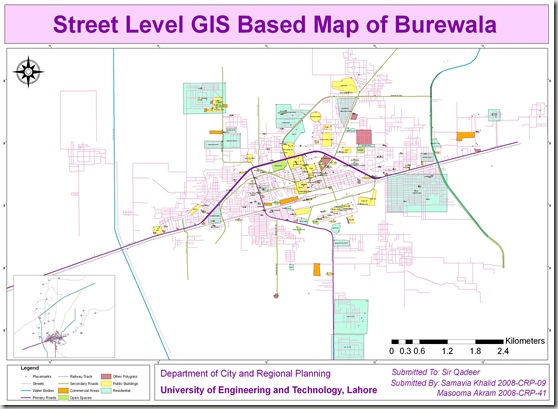
Street Level GIS Map of Burewala
Burewala (Urdu: بورے والا) is a city of Vehari District in southern Punjab, Pakistan. It is located at 30°10’0N 72°39’0E and has an altitude of 133 metres (439 feet).[1] It is the 30th biggest city in Pakistan by population.[3] The city of Burewala is the headquarters of Burewala Tehsil, an administrative subdivision of the district.[4] It is located 1035 km away from Karachi, 187 km from Faisalabad, 208 km from Lahore, 135 km from Multan, 35 km from Vehari. 40 km from Arifwala,75 km from Pakpattan and 103 km from Bahawalpur. Read More>>
This GIS map has been been prepared by Samavia Khalid and Masooma Ikram under our supervision. They are Urban Planners from Department of City & Regional Planning, University of Engineering & Technology, Lahore.
Methodology Adopted:
Street level mapping has been completed using high resolution images (0.6-1m) from Google Earth dating September 26, 2009. Detailed process is mentioned in the tutorial HERE.
Contents:
- Data Layers:
- Primary Roads
- Secondary Roads
- Tertiary Roads/ Streets
- Water Bodies
- Railway Lines
- Points of Interest (Hospitals, Educational Buildings, Public Buildings, Mosques etc)
- Area features (Parks, open spaces, Built up areas etc)
2. Coverage:
- 308 Square Kilometer
Availability:
Data is available in KML and ESRI Shape file formats.
Get Data:
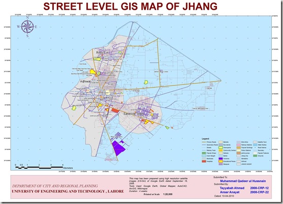
Street Level GIS Map of Jhang
Jhang (Punjabi, Urdu: جھنگ) is the principal city of Jhang District in the Punjab province of Pakistan. It is situated on the east bank of theChenab river at a latitude of 31.15° N and longitude of 72.22°E[1]. Read More>>
This GIS map has been been prepared by Tayyabah Ahmad and Ansar Inayat under our supervision. They are Urban Planners from Department of City & Regional Planning, University of Engineering & Technology, Lahore.
Methodology Adopted:
Street level mapping has been completed using high resolution images (0.6-1m) from Google Earth dating September 16, 2006. Detailed process is mentioned in the tutorial HERE.
Contents:
- Data Layers:
- Primary Roads
- Secondary Roads
- Tertiary Roads/ Streets
- Water Bodies
- Railway Lines
- Points of Interest (Hospitals, Educational Buildings, Public Buildings, Mosques etc)
- Area features (Parks, open spaces, Built up areas etc)
2. Coverage:
- 118.05 Square Kilometer
Availability:
Data is available in KML and ESRI Shape file formats.
Get Data:
If you want to acquire this data, use the Request Data Form to share your research and need of this data.
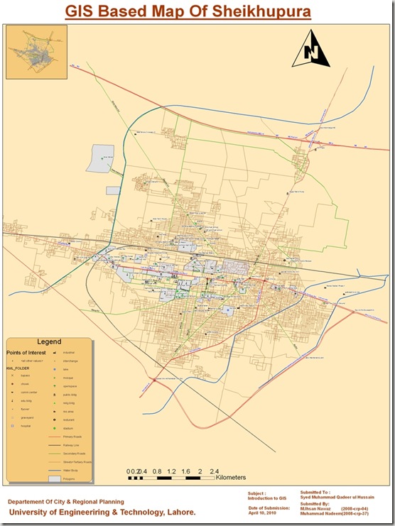
Street Level GIS Map of Sheikhupura
This map has been been prepared by Ihsan Nawaz and Muhammad Nadeem under our supervision. They are Urban Planners from Department of City & Regional Planning, University of Engineering & Technology, Lahore.
Methodology Adopted:
Street level mapping has been completed using high resolution images (0.6-1m) from Google Earth dating October 12, 2009. Detailed process is mentioned in the tutorial HERE.
Contents:
- Data Layers:
- Primary Roads
- Secondary Roads
- Tertiary Roads/ Streets
- Water Bodies
- Railway Lines
- Points of Interest (Hospitals, Educational Buildings, Public Buildings, Mosques etc)
- Area features (Parks, open spaces, Built up areas etc)
2. Coverage:
- 115.70 Square Kilometer
Availability:
Data is available in KML and ESRI Shape file formats.
Get Data:
Street Level GIS Map of Sahiwal
Sahiwal (Punjabi, Urdu: ساہیوال) is a city in Punjab, Pakistan. It is the administrative centre of Sahiwal District and Sahiwal Division.The districts of Okara and Pakpattan are under Sahiwal division. Sahiwal lies approximately 180 km from the major city of Lahore. And it is the biggest city between Lahore and Multan. Sahiwal District is included in the former Multan Division and lies between 30-39 north latitude and 73-06 longitude. The city lies in the densely populated region between the Sutlej and Ravi rivers. Irrigation in the region is provided by the Bari Doab Canal system. The principal crops are wheat, cotton, tobacco, legumes, and oilseeds. Cotton goods and lacquered woodwork are manufactured. About 18 miles Southwest of Sahiwal is Harappa, an ancient city of the world, oldest urban center of Harappan or Indus civilization in South Asia. About 28 miles (45 km) west of Sahiwal, at Kamalia, is the site of a Malli city captured by Alexander the Great in 325 bc. Pop. (1998) city, 207,388. The people of Sahiwal are known as Sahiwalians. This city got his name from the first inhibitors of this city the sahis (a jutt sub-tribe or cast). Sahiwal was named as Montgomery city before 1966. In 1966 a famous legendary politician Mufti Zia-ul-Hasan changed its name to Sahiwal. Read More>>
This map has been been prepared by Muhammad Umair and Hassan Ali. They are Urban Planners from Department of City & Regional Planning, University of Engineering & Technology, Lahore.
Methodology Adopted:
Street level mapping has been completed using high resolution images (0.6-1m) of Google Earth dating August 24, 2006 within a period of two months. Detailed process is mentioned in the tutorial HERE.
Contents:
- Data Layers:
- Primary Roads
- Secondary Roads
- Tertiary Roads/ Streets
- Water Bodies
- Railway Lines
- Points of Interest (Hospitals, Educational Buildings, Public Buildings, Mosques, Hotels, Banks, Petrol Pumps etc)
-
Area features (Parks, open spaces, Built up areas, Graveyards, Housing Schemes, water bodies etc)
2. Coverage:
- 70 Square Kilometer
Availability:
Data is available in KML and ESRI Shape file formats.


