Satellite Image Pakistan Flood 10 August 2010

Relying on NASA Earth Observatory on Natural Hazards, following image has been geo-referencing and converted to KML:

  1. 10 August 2010

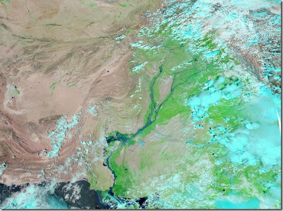
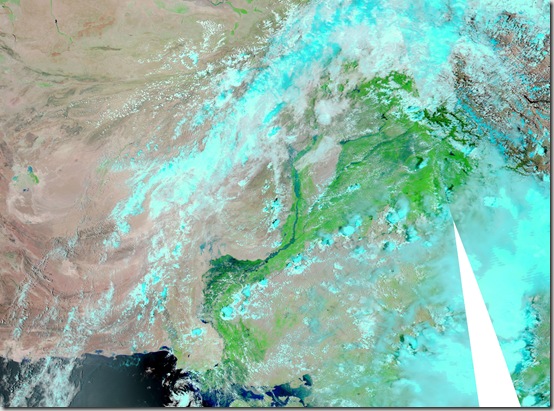
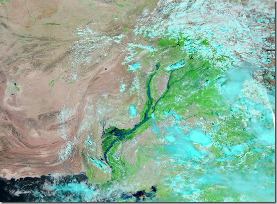
The Moderate Resolution Imaging Spectroradiometer (MODIS) on NASA’sAqua satellite captured this image of Pakistan. This image uses a combination of infrared and visible light to increase the contrast between water and land. Water appears in varying shades of blue, vegetation is green, and bare ground is pinkish brown. Clouds are bright turquoise.

pakistan_amo_10 Aug 2010

                                        .::Click HERE to request for this data set::.

Satellite Image Pakistan Flood 08 August 2010

Relying on NASA Earth Observatory on Natural Hazards, following image has been geo-referencing and converted to KML:

  1. 08 August 2010

The Moderate Resolution Imaging Spectroradiometer (MODIS) on NASA’sAqua satellite captured this image of Pakistan. This image uses a combination of infrared and visible light to increase the contrast between water and land. Water appears in varying shades of blue, vegetation is green, and bare ground is pinkish brown. Clouds are bright turquoise.

pakistan_amo_08 Aug 2010

                                       .::Click HERE to request for this data set::.
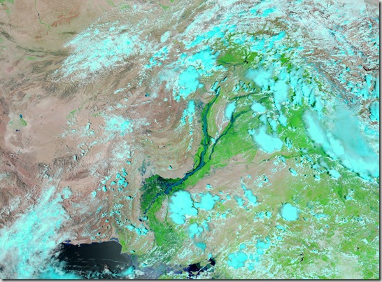
Satellite Image Pakistan Flood 14 August 2009

Relying on NASA Earth Observatory on Natural Hazards, following image has been geo-referencing and converted to KML:

  1. 14 August 2009

The Moderate Resolution Imaging Spectroradiometer (MODIS) on NASA’sAqua satellite captured this image of Pakistan. This image uses a combination of infrared and visible light to increase the contrast between water and land. Water appears in varying shades of blue, vegetation is green, and bare ground is pinkish brown. Clouds are bright turquoise.

pakistan_amo_14 Aug 2009

                                        .::Click HERE to request for this data set::.
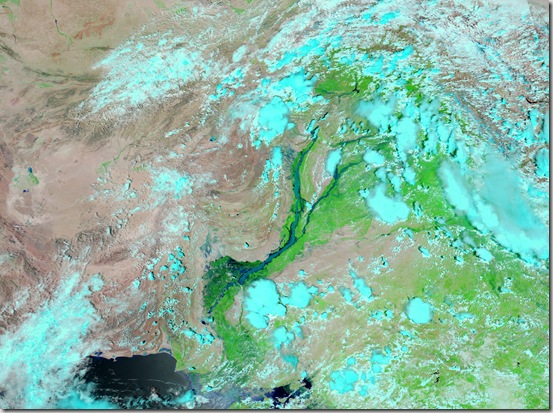
Satellite Image Pakistan Flood 15 August 2010

Relying on NASA Earth Observatory on Natural Hazards, following image has been geo-referencing and converted to KML:

  1. 15 August 2010

The Moderate Resolution Imaging Spectroradiometer (MODIS) on NASA’sAqua satellite captured this image of Pakistan. This image uses a combination of infrared and visible light to increase the contrast between water and land. Water appears in varying shades of blue, vegetation is green, and bare ground is pinkish brown. Clouds are bright turquoise.

pakistan_amo_15 Aug 2010

                                     .::Click HERE to request for this data set::.
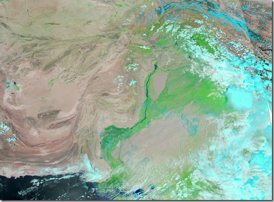
Satellite Image Pakistan Flood 30 July 2010

Relying on NASA Earth Observatory on Natural Hazards, following image has been geo-referencing and converted to KML:

  1. 30 July 2010

The Moderate Resolution Imaging Spectroradiometer (MODIS) on NASA’sAqua satellite captured this image of Pakistan. This image uses a combination of infrared and visible light to increase the contrast between water and land. Water appears in varying shades of blue, vegetation is green, and bare ground is pinkish brown. Clouds are bright turquoise.

pakistan_amo_30 July 2010_lrg

                                         .::Click HERE to request for this data set::.
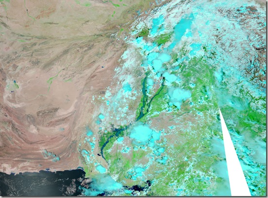
Satellite Image Pakistan Flood 17 August 2010

Relying on NASA Earth Observatory on Natural Hazards, following image has been geo-referencing and converted to KML:

  1. 17 August 2010

The Moderate Resolution Imaging Spectroradiometer (MODIS) on NASA’sAqua satellite captured this image of Pakistan. This image uses a combination of infrared and visible light to increase the contrast between water and land. Water appears in varying shades of blue, vegetation is green, and bare ground is pinkish brown. Clouds are bright turquoise.

pakistan_amo_17 Aug 2010_lrg

                                         .::Click HERE to request for this data set::.
Research Assistant GIS (26 May 2011)

  • Job Location: SSRI Pindi Bhattian & SFRI Lahore
  • Country: Pakistan
  • Positions: 1
  • Job Type: Service Contract
  • Department: Research
  • Last Date: 09 June, 2011

Bio Saline II (October 2006 – June 2012) aims at developing community driven sustainable farming systems for the rehabilitation of waterlogged and salt affected lands to improve livelihoods in three districts of Punjab namely Hafizabad, Jhang and Sargodha.
The Assistant Research Officer – GIS (ARO-GIS.) will report the Project Manager and Director SSRI, Pindi Bhattian.


Duties and Responsibilities:
§ To extend support in survey on salt affected soils of Sargodha and Hafizabad Districts through using GPS technology
§ Be responsible for the collection, authentication, recording and suitable presentation of existing data from various sources, including topographic maps, satellite images, and survey reports in order to create a comprehensive, spatially related information system. Initially confined to the immediate Project Area and if possible of the whole province ,
§ Collect and analyze data from the satellite receiving station and disseminate information to relevant departments/agencies.
§ Carry out field checks of data of all kinds, including the location of features and villages using the Global Positioning System equipment
§ To prepare GIS Maps.
§ Any other assignment entrusted by the Director SSRI and PM, Bio Saline-II project.

                                                 Apply Online Here

Jobs in Urban Unit Lahore (May 2011)

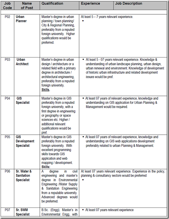
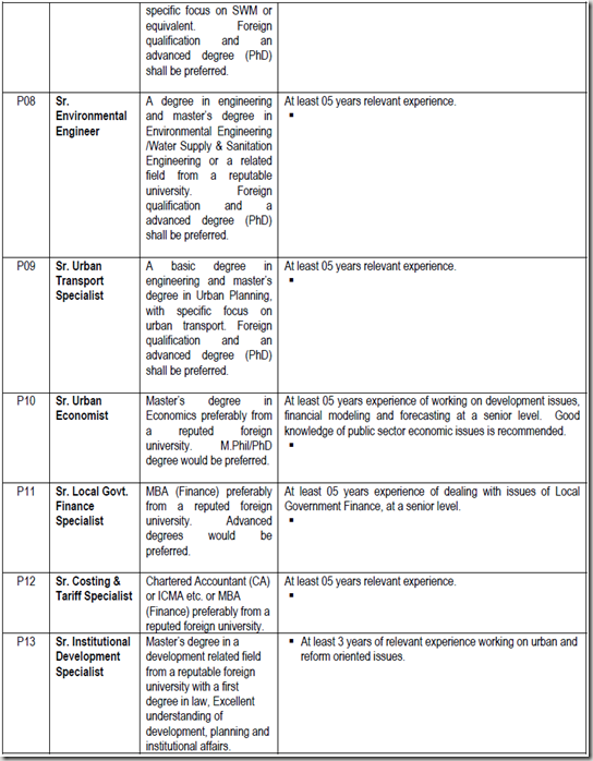
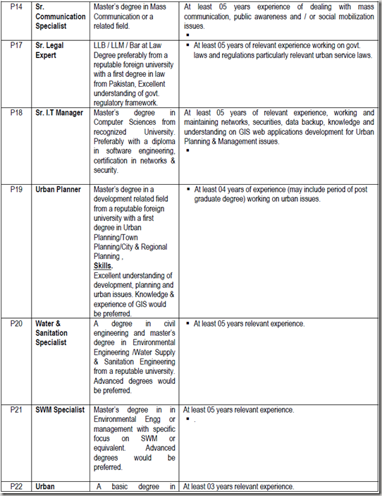
The Urban Unit is looking for specialists in various urban fields including GIS, Urban planning, solid waster management, environment engineering, transportation, environment etc. Summary of the job positions is given below. imageimageimageimage
Please send your CV directly to the Project Director, Urban Unit, at nasir_dsp@yahoo.com.

Note: This information has been shared by Human Resource Department of  Urban Unit. PakGIS is not responsible for any dealings between applicant and Urban Unit. We are merely sharing information about availability of jobs or openings in different organization so that others may benefit from that.

Satellite Image Pakistan Flood 02 September 2010

Relying on NASA Earth Observatory on Natural Hazards, following image has been geo-referencing and converted to KML:

  1. 02 September 2010

The Moderate Resolution Imaging Spectroradiometer (MODIS) on NASA’sAqua satellite captured this image of Pakistan. This image uses a combination of infrared and visible light to increase the contrast between water and land. Water appears in varying shades of blue, vegetation is green, and bare ground is pinkish brown. Clouds are bright turquoise.

pakistan_amo_02 Sep 2010

                                          .::Click HERE to request for this data set::.
WebGIS Expert Required in Islamabad (17 June 2011)

The Federal Institute for Geosciences and Natural Resources is looking for an WebGIS expert in Islamabad.

Knowledge & Skills:

1. Master in GIS or Computer Science
2. Excellent ArcGIS Skills
3. CMS skills
4. WebGIS/Webmapping skills and WebGIS project references
5. Good communication skills, in English

Applications are invited with following details:
List of recent GIS and WebGIS related jobs performed, availability during next 1 month
Contact Information

Send your applications to ingo.hoelzle@bgr.de as early as possible.

Note: This information has been shared by Ingo Hoelzle through a comment HERE. PakGIS is not responsible for any dealings between applicant and employer. We are sharing information about availability of jobs or openings in different organization so that others may benefit from that.