Satellite Image Pakistan Flood 15 August 2010

Relying on NASA Earth Observatory on Natural Hazards, following image has been geo-referencing and converted to KML:

  1. 15 August 2010

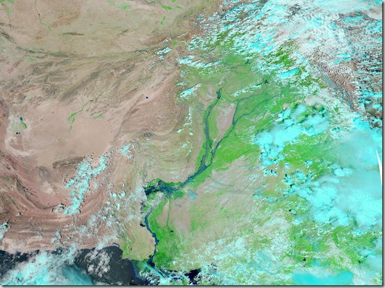
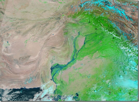
The Moderate Resolution Imaging Spectroradiometer (MODIS) on NASA’sAqua satellite captured this image of Pakistan. This image uses a combination of infrared and visible light to increase the contrast between water and land. Water appears in varying shades of blue, vegetation is green, and bare ground is pinkish brown. Clouds are bright turquoise.

pakistan_amo_15 Aug 2010

                                     .::Click HERE to request for this data set::.

Satellite Image Pakistan Flood 30 July 2010

Relying on NASA Earth Observatory on Natural Hazards, following image has been geo-referencing and converted to KML:

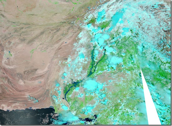
  1. 30 July 2010

The Moderate Resolution Imaging Spectroradiometer (MODIS) on NASA’sAqua satellite captured this image of Pakistan. This image uses a combination of infrared and visible light to increase the contrast between water and land. Water appears in varying shades of blue, vegetation is green, and bare ground is pinkish brown. Clouds are bright turquoise.

pakistan_amo_30 July 2010_lrg

                                         .::Click HERE to request for this data set::.

Satellite Image Pakistan Flood 17 August 2010

Relying on NASA Earth Observatory on Natural Hazards, following image has been geo-referencing and converted to KML:

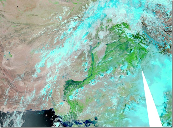
  1. 17 August 2010

The Moderate Resolution Imaging Spectroradiometer (MODIS) on NASA’sAqua satellite captured this image of Pakistan. This image uses a combination of infrared and visible light to increase the contrast between water and land. Water appears in varying shades of blue, vegetation is green, and bare ground is pinkish brown. Clouds are bright turquoise.

pakistan_amo_17 Aug 2010_lrg

                                         .::Click HERE to request for this data set::.

Satellite Image Pakistan Flood 02 September 2010

Relying on NASA Earth Observatory on Natural Hazards, following image has been geo-referencing and converted to KML:

  1. 02 September 2010

The Moderate Resolution Imaging Spectroradiometer (MODIS) on NASA’sAqua satellite captured this image of Pakistan. This image uses a combination of infrared and visible light to increase the contrast between water and land. Water appears in varying shades of blue, vegetation is green, and bare ground is pinkish brown. Clouds are bright turquoise.

pakistan_amo_02 Sep 2010

                                          .::Click HERE to request for this data set::.

Satellite Image Pakistan Flood 29 August 2010

Relying on NASA Earth Observatory on Natural Hazards, following image has been geo-referencing and converted to KML:

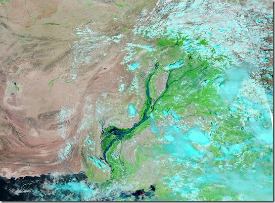
  1. 29 August 2010

The Moderate Resolution Imaging Spectroradiometer (MODIS) on NASA’sAqua satellite captured this image of Pakistan. This image uses a combination of infrared and visible light to increase the contrast between water and land. Water appears in varying shades of blue, vegetation is green, and bare ground is pinkish brown. Clouds are bright turquoise.

pakistan_tmo_29 Aug 2010

                                          .::Click HERE to request for this data set::.

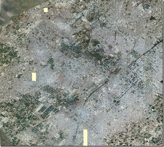
Satellite Image of Faisalabad

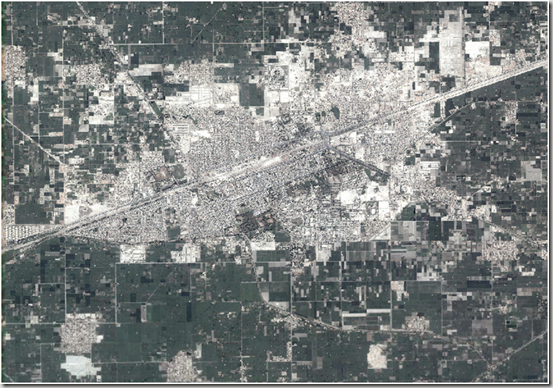
 Faisalabad (Punjabi, Urdu: فیصل آباد) is a city in the province of Punjab, Pakistan. It was formerly known as Lyallpur. Faisalabad is the third largest city in Pakistan after Karachi and Lahore. Before the foundation of the city in 1880, the area was very thinly populated. The population has risen from 9,171 in 1901 to 179,000 in 1951 and to 2,009,000 in 1998.[2] The larger Faisalabad district had a population of about 5.4 million in 1998.[3]

It is an important industrial centre west of Lahore. The city-district of Faisalabad is bound on the north by the districts of Gujranwala andSheikhupura, on the east by Sahiwal, on the south by Toba Tek Singh and on the west by Jhang. It is 1,135 km (705 mi) from Karachi, 128 km (80 mi) from Lahore, 350 km (220 mi) from Islamabad/Rawalpindi, 187 km (116 mi) from Burewala, and 70 km (43 mi) from Jhang.

The city is at a road and railway junction, which has played an influential role in the development of Faisalabad’s trade and economy. The surrounding countryside, irrigated by the Lower Chenab River, has seen expanded production of cotton, wheat, vegetables, and fruits, which form 25% of Pakistan’s exports. The city is also an industrial centre with major railway repair yards, engineering works, and mills thatprocess sugar, flour, and oil seed. Produce includes super phosphates, cotton and silk textiles, hosiery, dyes, agricultural equipment, andghee (clarified butter). Faisalabad is also the site of the prestigious University of Agriculture, founded in 1909.

Faisalabad is the largest industrial city of Pakistan and its textile capital, specialising in export-oriented manufactured goods.” Source: Wikipedia

Here is the metadata for the available image. Complete Faisalabad urban area comes in three patches with us. Here is the first patch, rest are coming soon…

DESCRIPTION

Faisalabad.ecw

WEST LONGITUDE

73° 00′ 18.7521" E

NORTH LATITUDE

31° 28′ 51.3489" N

EAST LONGITUDE

73° 09′ 50.3459" E

SOUTH LATITUDE

31° 20′ 32.1941" N

PROJ_DESC

Geographic (Latitude/Longitude) / WGS84 / arc degrees

PROJ_DATUM

WGS84

PROJ_UNITS

arc degrees

EPSG_CODE

4326

COVERED AREA

89.81 sq mi

NUM COLUMNS

29598

NUM ROWS

25847

NUM_BANDS

3

PIXEL WIDTH

0.0000054 arc degrees

PIXEL HEIGHT

0.0000054 arc degrees

BIT_DEPTH

24

PROJ_NAME

GEODETIC

DATUM_NAME

WGS84

TARGET_COMPRESSION

1:10

Screen shot of the Image:

image 

                                    .::Click HERE to request for this data set::.

Satellite Image of Vehari

Here is the metadata of the satellite image of Vehari:

DESCRIPTION

vehari.ecw

WEST LONGITUDE

72° 18′ 58.5126" E

NORTH LATITUDE

30° 04′ 3.3672" N

EAST LONGITUDE

72° 23′ 32.4957" E

SOUTH LATITUDE

30° 00′ 53.8632" N

PROJ_DESC

Geographic (Latitude/Longitude) / WGS84 / arc degrees

PROJ_DATUM

WGS84

PROJ_UNITS

arc degrees

EPSG_CODE

4326

COVERED AREA

16.58 sq mi

NUM COLUMNS

11335

NUM ROWS

7840

NUM_BANDS

3

PIXEL WIDTH

0.0000067 arc degrees

PIXEL HEIGHT

0.0000067 arc degrees

BIT_DEPTH

24

PROJ_NAME

GEODETIC

DATUM_NAME

WGS84

TARGET_COMPRESSION

1:10

Screen Shot of the Image:image

                                  .::Click HERE to request for this data set::.

Satellite Image of Liaqatpur (Rahim yar Khan)

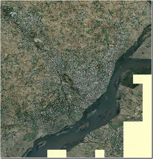
Liaquatpur or Liaqatpur is a town and seat of Liaquatpur Tehsil in Rahim Yar Khan District, Pakistan. It is located at 28°55’60N 70°57’0E with an altitude of 95 metres (314 feet).[1]

It is situated exactly between the main cities of Bahawalpur and Rahim Yar Khan. The main railway line connecting Lahore and Karachi passes through this city and a small railway station is also in this city.  (Wikipedia)

Metadata of the satellite image is given below:

DESCRIPTION

Liaqatpur19.ecw

WEST LONGITUDE

70° 55′ 48.2465" E

NORTH LATITUDE

28° 57′ 7.0591" N

EAST LONGITUDE

70° 58′ 9.9187" E

SOUTH LATITUDE

28° 54′ 55.9313" N

PROJ_DESC

Geographic (Latitude/Longitude) / WGS84 / arc degrees

PROJ_DATUM

WGS84

PROJ_UNITS

arc degrees

EPSG_CODE

4326

COVERED AREA

6 sq mi

NUM COLUMNS

7336

NUM ROWS

6790

NUM_BANDS

3

PIXEL WIDTH

0.0000054 arc degrees

PIXEL HEIGHT

0.0000054 arc degrees

BIT_DEPTH

24

PROJ_NAME

GEODETIC

DATUM_NAME

WGS84

TARGET_COMPRESSION

1:10

Screen Shot of Image:

clip_image002[4]

                                      .::Click HERE to request for this data set::.

Satellite Image of Jhelum City

Below is the metadata of the image of Jhelum city available here:

DESCRIPTION

Jhelum19.ecw

Image Date

June 2009

WEST LONGITUDE

73° 40′ 5.3124" E

NORTH LATITUDE

32° 59′ 55.0067" N

EAST LONGITUDE

73° 46′ 13.3587" E

SOUTH LATITUDE

32° 53′ 24.5972" N

PROJ_DESC

Geographic (Latitude/Longitude) / WGS84 / arc degrees

PROJ_DATUM

WGS84

PROJ_UNITS

arc degrees

EPSG_CODE

4326

COVERED AREA

44.47 sq mi

NUM COLUMNS

19058

NUM ROWS

20216

NUM_BANDS

3

PIXEL WIDTH

0.0000054 arc degrees

PIXEL HEIGHT

0.0000054 arc degrees

BIT_DEPTH

24

PROJ_NAME

GEODETIC

DATUM_NAME

WGS84

TARGET_COMPRESSION

1:29

Screen Shot of Image:image

                           .::Click HERE to request for this data set::.

Satellite Image of Lahore

Satellite image of Lahore at good resolution is available at PKMaps. These can be used for any GIS/RS assignment and analysis.

Source of quoted material: http://pkmaps.freeforums.org/lahore-satellite-imagery-at-18x-zoom-t31.html

You can find all the Yahoo imagery you need for mapping Lahore at 18x zoom level at the following RapidShare download link:

http://rapidshare.com/files/176314336/lahore_yahoo_satalite_1.zip
http://rapidshare.com/files/176316142/lahore_yahoo_satalite_2.zip
http://rapidshare.com/files/176317579/lahore_yahoo_satalite_3.zip
http://rapidshare.com/files/176320007/lahore_yahoo_satalite_4.zip
http://rapidshare.com/files/176322298/lahore_yahoo_satalite_5.zip
http://rapidshare.com/files/176321238/lahore_yahoo_satalite_6.zip
http://rapidshare.com/files/176324063/lahore_yahoo_satalite_7.zip
http://rapidshare.com/files/176325590/lahore_yahoo_satalite_8.zip
http://rapidshare.com/files/176324388/lahore_yahoo_satalite_9.zip

These zips contain the Ozi Explorer .map files and embeded merged images in jpeg format.
They have been downloaded from Yahoo using gMapMaker.
There are 9 files in total so that Lahore can be split up into 9 portions.
You can use these Ozi map files along with their image files in GPSMapEdit for your mapping.
Depending on where you unzip the file contects you may need to edit with a text editor the .jpg file path on 3rd line in each .map (Ozi Explorer file) to point to the right location of its associated .jpg file for the .map file to work.
The original jpeg tiles from Yahoo at 18x zoom downloaded by gMapMaker can be found at the following rapishare links:

http://rapidshare.com/files/176831705/yahoo_satallite_imagery_at_18x.part1.rar
http://rapidshare.com/files/176833586/yahoo_satallite_imagery_at_18x.part2.rar
http://rapidshare.com/files/176834619/yahoo_satallite_imagery_at_18x.part3.rar

PS: You will need to download all these .rar files and run winrar to extract them to one folder.
Mobile GMaps can users also benifit from these files.