Introducing Unified Cadastral System Model: Reforming & Modernizing Land Governance in Pakistan

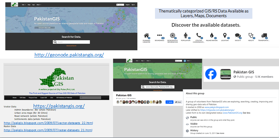
The Specification Document for the Unified Cadastral System Model is now available on the PakistanGIS GeoNode Platform.

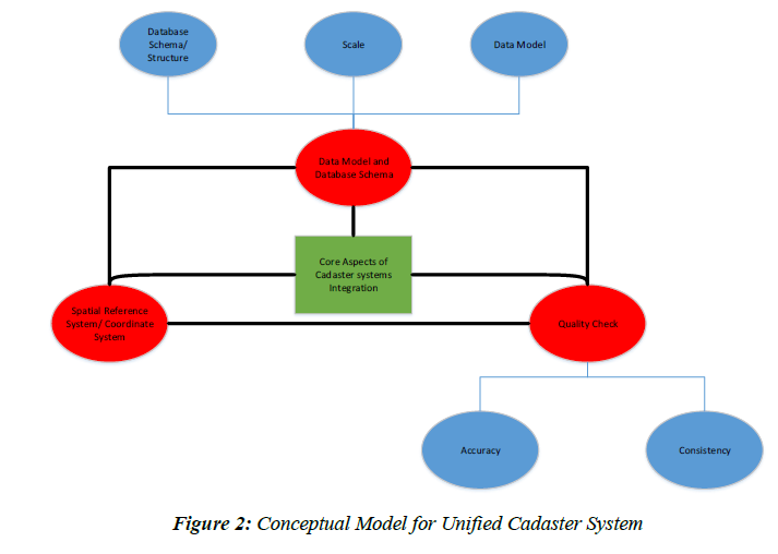
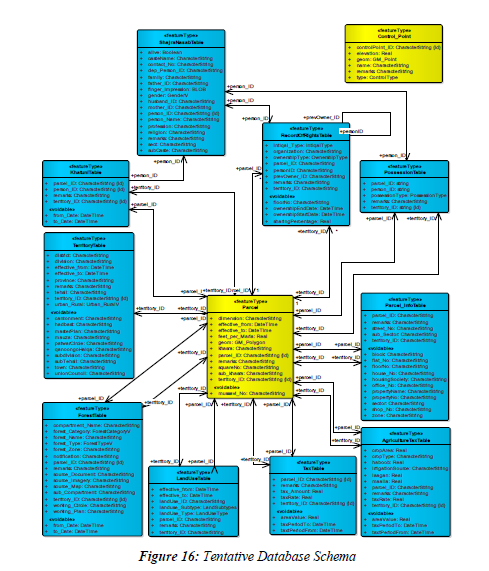
Developed and released by Survey of Pakistan, this document provides a standardized framework for reforming and modernizing the cadastral system of Pakistan. The sample model has been built within the ArcGIS environment.

What’s Inside?

  • Clear definitions of key cadastral components & layers
  • Guidelines for data collection, storage, sharing & maintenance
  • Metadata standards aligned with international best practices
  • Proposed workflows, stakeholder roles & responsibilities

Why It Matters?

  • Transparent & digitized land records
  • Reduced land disputes through boundary clarity
  • Stronger foundation for urban planning & infrastructure
  • Modernization of land governance with GIS integration

What You Can Do?

  • Read the Document — get familiar with its details
  • Share this Post — to raise awareness among surveyors, planners and academics
  • Contribute Your Feedback — your input can help refine implementation
  • Apply It in Your Work — mapping, planning, land administration & beyond

Access the full document here: http://geonode.pakistangis.org/documents/93

Together, let’s build a transparent, modern, and accessible cadastral system across Pakistan.

Mapping Minds, Shaping the World #GISDay2024

Today on November 20, 2024, we join global community in celebrating the 25thAnniversary of GIS Day under the theme “Mapping Minds, Shaping the World”. This theme highlights how human creativity and technological advancements come together to transform our world.

Our World by ESRI

We at City Pulse (Pvt.) Ltd. are excited to be part of this global movement. Inspired by the visionary Ralph Nader, who motivated the creation of GIS Day in 1999, we are committed to integrating and building GIS based solutions in key thematic areas of habitat planning, agro-informatics, socio-economic studies, environment, disaster management, water solutions etc. Our goal is to better understand, navigate, and shape communities at rural, urban and regional scale.

Through GIS, we tend to change the traditions, uncover trends, empower informed & smart decision-making and contribute to sustainable development of individuals and communities; our people and the planet, now and into the future.

In line with our efforts, we are also driving the #PakistanGIS initiative—a voluntary movement aimed at building a strong, connected network of GIS professionals, map enthusiasts, students, and researchers. Together, we can innovate, share knowledge, and contribute to society’s growth through the power of geospatial technology.

Current Modes of PakistanGIS: PakistanGISGeonode, PakistanGIS webpage, and Pakistan GIS Facebook Group

Join us on this journey! Let’s connect, innovate, and shape the future world together with GIS.